
File:LocationGuineaBissau.png
Ala nang mas malino pa.
LocationGuineaBissau.png (250 × 115 pixel, sukad ning simpan: 5 KB, MIME type: image/png)
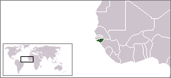
Location map for the Guinea-Bissau.
Originally created for English Wikipedia by Vardion.
| |
This work has been released into the public domain by its author, Vardion, at the English Wikipedia project. This applies worldwide. In case this is not legally possible: |

|
File:LocationGuineaBissau.svg is a vector version of this file. It should be used in place of this PNG file when not inferior.
File:LocationGuineaBissau.png → File:LocationGuineaBissau.svg
For more information, see Help:SVG. |
 |
Amlat ning simpan (File history)
Mag-click kang petsa/oras ba meng akit ing itsura ning simpan aniang panaun a ita.
| Petsa/Oras | Thumbnail | Sukad | Talagamit | Komentu/Puna | |
|---|---|---|---|---|---|
| salukuyan | 05:09, 12 Disyembri 2004 | | 250 × 115 (5 KB) | EugeneZelenko | Location map for the Guinea-Bissau.<br/>Originally created for English Wikipedia by Vardion.<br/>{{PD}}<br/>Category:Country locator maps |
↓Suglung kareng simpan (''file links'')
Ing tutuking page links kaniting simpan (file):
Global file usage
The following other wikis use this file:
- Usage on ar.wikipedia.org
- Usage on ar.wikinews.org
- Usage on bg.wikipedia.org
- Usage on bs.wikipedia.org
- Usage on ca.wikipedia.org
- Usage on ca.wikinews.org
- Usage on de.wikipedia.org
- Usage on de.wiktionary.org
- Usage on en.wikipedia.org
- Usage on en.wikinews.org
- Usage on en.wikivoyage.org
- Usage on en.wiktionary.org
- Usage on eo.wikipedia.org
- Usage on es.wikipedia.org
- Usage on ff.wikipedia.org
- Usage on frp.wikipedia.org
- Usage on fr.wikipedia.org
- Usage on fr.wikinews.org
- Usage on he.wikivoyage.org
- Usage on hif.wikipedia.org
- Usage on hr.wikipedia.org
- Usage on hr.wiktionary.org
View more global usage of this file.