
File:Map of California highlighting Mariposa County.svg

Size of this PNG preview of this SVG file: 523 × 599 pixels. Other resolutions: 209 × 240 pixels | 419 × 480 pixels | 670 × 768 pixels | 894 × 1,024 pixels | 1,787 × 2,048 pixels | 1,022 × 1,171 pixels.
Ing minunang simpan (file) (SVG file, masasabing 1,022 × 1,171 pixels, dagul ning simpan: 505 KB)
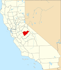
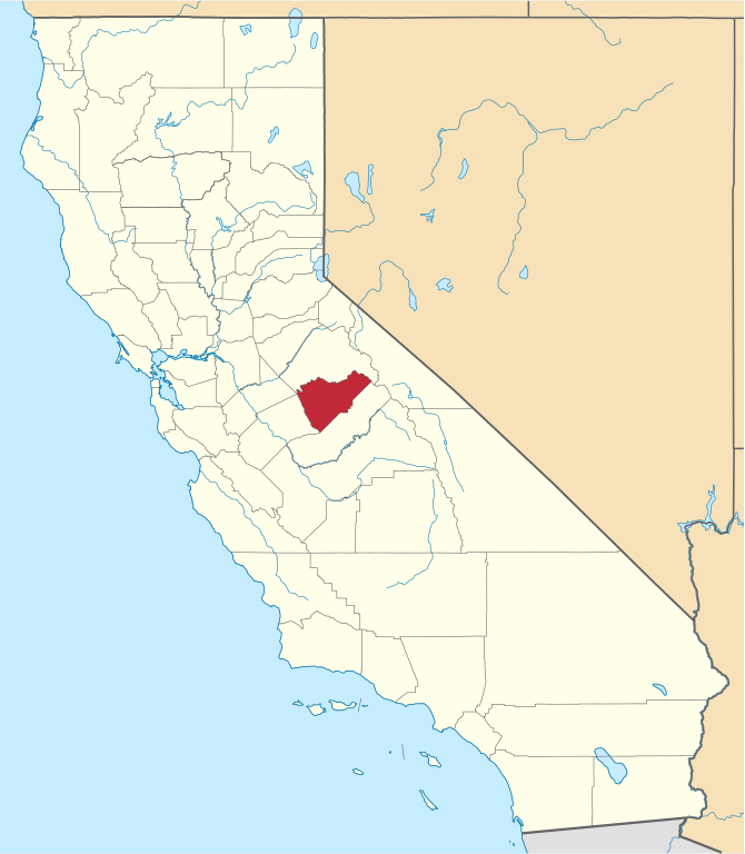
English: Locator map of Mariposa County, in California.
- Credits
- David Benbennick made this map.
- For more information, see Commons:United States county locator maps.
| I, the copyright holder of this work, release this work into the public domain. This applies worldwide. In some countries this may not be legally possible; if so: I grant anyone the right to use this work for any purpose, without any conditions, unless such conditions are required by law. |
Amlat ning simpan (File history)
Mag-click kang petsa/oras ba meng akit ing itsura ning simpan aniang panaun a ita.
| Petsa/Oras | Thumbnail | Sukad | Talagamit | Komentu/Puna | |
|---|---|---|---|---|---|
| salukuyan | 16:01, 26 Nobyembri 2016 | | 1,022 × 1,171 (505 KB) | Spartan7W | Update HQ map |
| 10:26, 12 Pebreru 2006 |  | 9,164 × 10,536 (229 KB) | David Benbennick | {{subst:User:Dbenbenn/clm|county=Mariposa County|state=California}} |
↓Suglung kareng simpan (''file links'')
Ing tutuking page links kaniting simpan (file):
Global file usage
The following other wikis use this file:
- Usage on ar.wikipedia.org
- Usage on az.wikipedia.org
- Usage on ban.wikipedia.org
- Usage on bpy.wikipedia.org
- Usage on ca.wikipedia.org
- Usage on ceb.wikipedia.org
- Usage on ce.wikipedia.org
- Usage on cs.wikipedia.org
- Usage on cy.wikipedia.org
- Usage on da.wikipedia.org
- Usage on de.wikipedia.org
- Usage on en.wikipedia.org
- List of counties in California
- Mariposa County, California
- Bootjack, California
- Mariposa, California
- Yosemite Valley, California
- Wawona, California
- Catheys Valley, California
- Coulterville, California
- Fish Camp, California
- Template:Mariposa County, California
- Buck Meadows, California
- Yosemite West, California
- Agua Fria, California
- El Portal, California
- Mormon Bar, California
- Mount Ophir, California
- Category:Wikipedia requested photographs in Mariposa County, California
- Midpines, California
- National Register of Historic Places listings in Mariposa County, California
- Indian Gulch, California
- User:Nyttend/County templates/CA/2
- Bear Valley, Mariposa County, California
- Ben Hur, California
- Briceburg, California
- Clearing House, California
- Darrah, California
- Dogtown, Mariposa County, California
- Foresta, California
- Hites Cove, California
- Hornitos, California
- Incline, California
- Jerseydale, California
- Mount Bullion, Mariposa County, California
View more global usage of this file.