
File:Altai republic map.png
Size of this preview: 626 × 600 pixels. Other resolutions: 251 × 240 pixels | 501 × 480 pixels | 804 × 770 pixels.
Ing minunang simpan (file) (804 × 770 pixel, sukad ning simpan: 46 KB, MIME type: image/png)
Sampulung (summary)
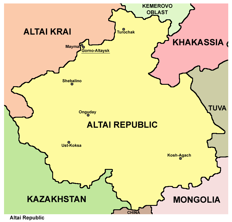
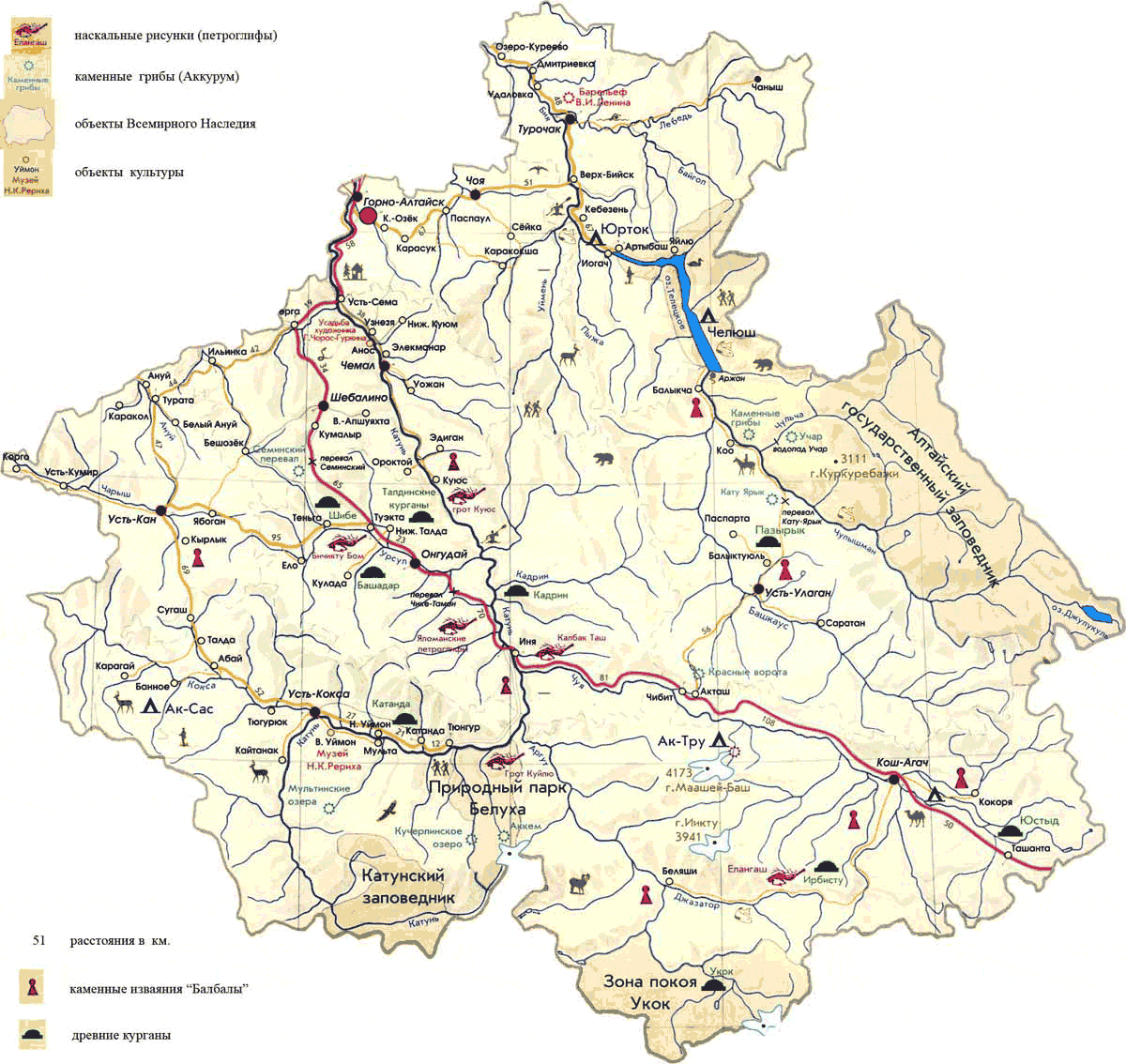
| Description | Map of Altai Republic, Russia. |
| Petsa | |
| Pikuanan | Own work |
| Maki-akda | PANONIAN |
Pamamie lisensia
I, the copyright holder of this work, hereby publish it under the following license:
| This file is made available under the Creative Commons CC0 1.0 Universal Public Domain Dedication. | |
| The person who associated a work with this deed has dedicated the work to the public domain by waiving all of their rights to the work worldwide under copyright law, including all related and neighboring rights, to the extent allowed by law. You can copy, modify, distribute and perform the work, even for commercial purposes, all without asking permission.
|
References
Maps from external links:
- http://www.altay-magazin.ru/images/altai_map9.jpg
- http://www.regions.newsall.ru/altai-rep/altai-rep.htm.gif
- https://www.usrbc.org/pics/Image/Russian%20Regions/Altai%20Republic/map_altay.gif
- http://www.stopwatchhut.com/places/330.jpg
- http://snowleopardblog.com/wp-content/uploads/2010/05/altai-republic-closeup-map.jpg
- http://altaifellowship.files.wordpress.com/2011/02/altai-districts-map4.jpg
- http://www.rusadv.com/Pictures/Russia/Regions/G_Altay.gif[dead link]
- http://www.altaiproject.org/wp-content/uploads/2011/07/AltaiMap.jpg
- http://www.rusnet.nl/i/encyclo/a/altay_rep_map.gif
- http://alt-kedr.ru/images/map_altay.jpg[dead link]
- http://www.vgorah.narod.ru/Pics/altay/mapraj.gif[dead link]
- http://loi.sscc.ru/bdm/nso/attr/sfo/img/altai_r.gif
- http://topmap.narod.ru/04/all/altay-phis-5-s.jpg
- http://mchs.altai-republic.ru/2/kartab.jpg[dead link]
- http://sibturizm.ru/info/kartirespaltai/Dosrespaltay.gif
- http://www.karta-russia.ru/maps/map-altay-karta.jpg
- http://loi.sscc.ru/bdm/nso/attr/zapsib/zapsib10.files/6-10a.gif archive copy at the Wayback Machine
- http://altay-valley.ru/s2/images/ra.jpg
- http://trasa.ru/img/regions/altay.gif
- http://sibturizm.ru/info/guide/altayrepublic.jpg
- http://syuv.ru/img/maps/regions/dorogi/big/karta-dorog-respublika_altay.png[dead link]
- http://www.newtek.pro/upload/images/Горноалтайск.gif archive copy at the Wayback Machine
- http://the-day-x.ru/wp-content/uploads/2012/02/b9db09bf2ace169d09207fa35e.jpg archive copy at the Wayback Machine
- http://molodost.ru/upload/image/22_03_10/450.jpg
- http://touringaltai.com/D://2011/03/altai_republic_map_large.jpg[dead link]
- http://www.htls.ru/peoples/russia/respublika_altay/map_bg.jpg
- http://www.hamulet.ru/wp-content/uploads/2010/10/Altay.jpg archive copy at the Wayback Machine
Largest cities and towns in Altai Republic:
- http://world-gazetteer.com/wg.php?x=&men=gcis&lng=en&des=wg&geo=-183&srt=npan&col=abcdefghinoq&msz=1500&geo=-3106[dead link]
Amlat ning simpan (File history)
Mag-click kang petsa/oras ba meng akit ing itsura ning simpan aniang panaun a ita.
| Petsa/Oras | Thumbnail | Sukad | Talagamit | Komentu/Puna | |
|---|---|---|---|---|---|
| salukuyan | 13:59, 20 Juliu 2012 | | 804 × 770 (46 KB) | PANONIAN | {{Information |Description=Map of Altai Republic, Russia. |Source={{own}} |Date=2012 |Author= PANONIAN |Permission= |other_versions= }} |
↓Suglung kareng simpan (''file links'')
Ing tutuking page links kaniting simpan (file):
Global file usage
The following other wikis use this file:
- Usage on ace.wikipedia.org
- Usage on alt.wikipedia.org
- Usage on be-tarask.wikipedia.org
- Usage on bn.wikipedia.org
- Usage on bs.wikipedia.org
- Usage on bxr.wikipedia.org
- Usage on crh.wikipedia.org
- Usage on da.wikipedia.org
- Usage on el.wikivoyage.org
- Usage on eo.wikipedia.org
- Usage on eu.wikipedia.org
- Usage on fa.wikipedia.org
- Usage on fi.wikipedia.org
- Usage on frr.wikipedia.org
- Usage on ga.wikipedia.org
- Usage on gl.wikipedia.org
- Usage on hi.wikipedia.org
- Usage on hr.wikipedia.org
- Usage on id.wikipedia.org
- Usage on incubator.wikimedia.org
- Usage on it.wikipedia.org
- Usage on ja.wikipedia.org
- Usage on ka.wikipedia.org
- Usage on ko.wikipedia.org
- Usage on kv.wikipedia.org
- Usage on ky.wikipedia.org
- Usage on la.wikipedia.org
- Usage on lt.wikipedia.org
- Usage on mdf.wikipedia.org
- Usage on mk.wikipedia.org
- Usage on mr.wikipedia.org
- Usage on ms.wikipedia.org
- Usage on myv.wikipedia.org
- Usage on nl.wikipedia.org
- Usage on nn.wikipedia.org
- Usage on pl.wikipedia.org
- Usage on pl.wiktionary.org
View more global usage of this file.