
File:CarteregionBasseNormandie.jpg
Ala nang mas malino pa.
CarteregionBasseNormandie.jpg (500 × 500 pixel, sukad ning simpan: 112 KB, MIME type: image/jpeg)
Sampulung (summary)
| Description |
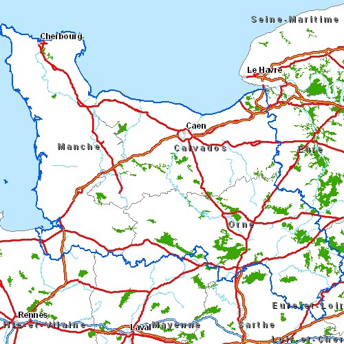
Carte routière de la région Basse-Normandie Légende : |
| Petsa | 06/05/2005 |
| Pikuanan | Cette carte est généreusement fournie par l'IAAT (Institut atlantique d'aménagement du territoire). From French Wiki, uploaded there by fr:Utilisateur:Archeos on 6-may-05 |
| Maki-akda | IAAT |
| Permission (Reusing this file) |
Je la place comme convenu avec eux sous licence GFDL |
Pamamie lisensia

|
Permission is granted to copy, distribute and/or modify this document under the terms of the GNU Free Documentation License, Version 1.2 or any later version published by the Free Software Foundation; with no Invariant Sections, no Front-Cover Texts, and no Back-Cover Texts. A copy of the license is included in the section entitled GNU Free Documentation License. |
| This file is licensed under the Creative Commons Attribution-Share Alike 3.0 Unported license. | ||
| ||
| This licensing tag was added to this file as part of the GFDL licensing update. |
Amlat ning simpan (File history)
Mag-click kang petsa/oras ba meng akit ing itsura ning simpan aniang panaun a ita.
| Petsa/Oras | Thumbnail | Sukad | Talagamit | Komentu/Puna | |
|---|---|---|---|---|---|
| salukuyan | 03:54, 6 Eneru 2006 | | 500 × 500 (112 KB) | Bansp | Carte routière de la région Basse-Normandie Légende : Image:Legendecartesregions.jpg * Cette carte est généreusement fournie par l'IAAT ([http://www.iaat.org Institut atlantique d'aménagement du territoire]) * Original: Je la place comme conve |
↓Suglung kareng simpan (''file links'')
Ing tutuking page links kaniting simpan (file):
Global file usage
The following other wikis use this file:
- Usage on ar.wikipedia.org
- Usage on ceb.wikipedia.org
- Usage on en.wikipedia.org
- Usage on es.wikipedia.org
- Usage on hr.wikipedia.org
- Usage on jv.wikipedia.org
- Usage on mk.wikipedia.org
- Usage on pa.wikipedia.org
- Usage on sh.wikipedia.org
- Usage on sr.wikipedia.org
- Usage on ta.wikipedia.org
- Usage on uk.wikipedia.org