
File:China-Gansu.png
Ala nang mas malino pa.
China-Gansu.png (268 × 218 pixel, sukad ning simpan: 16 KB, MIME type: image/png)
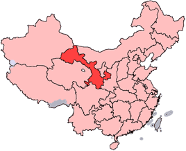
en: Location of Gansu Province in the People's Republic of China. See Locator maps of province-level divisions of the People's Republic of China for more information.
zh: 甘肅省在中華人民共和國的位置。另見Locator maps of province-level divisions of the People's Republic of China。

|
Permission is granted to copy, distribute and/or modify this document under the terms of the GNU Free Documentation License, Version 1.2 or any later version published by the Free Software Foundation; with no Invariant Sections, no Front-Cover Texts, and no Back-Cover Texts. A copy of the license is included in the section entitled GNU Free Documentation License. |
| This file is licensed under the Creative Commons Attribution-Share Alike 3.0 Unported license. | ||
| ||
| This licensing tag was added to this file as part of the GFDL licensing update. |

|
File:Map of PRC Gansu.svg is a vector version of this file. It should be used in place of this PNG file when not inferior.
File:China-Gansu.png → File:Map of PRC Gansu.svg
For more information, see Help:SVG. |
 |
Amlat ning simpan (File history)
Mag-click kang petsa/oras ba meng akit ing itsura ning simpan aniang panaun a ita.
| Petsa/Oras | Thumbnail | Sukad | Talagamit | Komentu/Puna | |
|---|---|---|---|---|---|
| salukuyan | 14:56, 15 Juliu 2005 | | 268 × 218 (16 KB) | Schaengel89~commonswiki | transparent background |
| 22:39, 4 Juniu 2005 |  | 268 × 218 (9 KB) | Ran | '''en''': Location of Gansu Province in the People's Republic of China. See Category:Locator maps of province-level divisions of the People's Republic of China for more information. '''zh''': 甘肅省在中華人民共和國的位置。另見[[:Cat |
↓Suglung kareng simpan (''file links'')
Ing tutuking page links kaniting simpan (file):
Global file usage
The following other wikis use this file:
- Usage on bn.wikipedia.org
- Usage on da.wikipedia.org
- Usage on de.wikipedia.org
- Usage on en.wikipedia.org
- Wikipedia:WikiProject Chinese provinces/Locator maps
- Xiahe County
- Yongjing County
- Daxia River
- Kongtong Mountains
- Subei Mongol Autonomous County
- Bairi Tibetan Autonomous County
- Zhuanglang County
- Huangyangchuan
- User:OldakQuill/temp
- Dunhuang Mogao International Airport
- Yongchang County
- Qingyang Airport
- Template:Gansu-geo-stub
- Xifeng, Qingyang
- Mazong Mountain
- Liancheng National Nature Reserve
- Longxi County
- Lintao County
- Min County
- Wushao Mountain
- 2008 Tibetan unrest
- Chongxin County
- Guanghe County
- Hezheng County
- Dongxiang Autonomous County
- Xihe County
- Wushan County, Gansu
- Qingshui County
- Qin'an County
- Gangu County
- Zhangjiachuan Hui Autonomous County
- Qinzhou, Tianshui
- Maiji, Tianshui
View more global usage of this file.