
File:Distrito Federal RA Plano Piloto.svg

Ing minunang simpan (file) (SVG file, masasabing 974 × 545 pixels, dagul ning simpan: 1.77 MB)

|
Standardization of derivative maps
Feel free to create derivations of this work, but if you want to illustrate a Wikipedia article with derivative works of this or similar maps of Brazil, please strictly follow the visual standard, nomenclature and classification already in use. All maps of Brazilian subdivisions are being adaptated or created in this way. We do not want to inhibit creativity but the pattern adopted here was presented and accepted by the Lusophone community and should be followed whenever possible. |
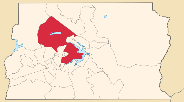
| Description | Map locator of Distrito Federal' administrative region I Plano Piloto | ||||||||
| Petsa | |||||||||
| Pikuanan | Own work | ||||||||
| Maki-akda | FORTES | ||||||||
| Permission (Reusing this file) |
I, the copyright holder of this work, hereby publish it under the following licenses:
This file is licensed under the Creative Commons Attribution 2.5 Generic license.
You may select the license of your choice. |

Amlat ning simpan (File history)
Mag-click kang petsa/oras ba meng akit ing itsura ning simpan aniang panaun a ita.
| Petsa/Oras | Thumbnail | Sukad | Talagamit | Komentu/Puna | |
|---|---|---|---|---|---|
| salukuyan | 15:26, 5 Abril 2020 | | 974 × 545 (1.77 MB) | Furious97 | Corrigindo cores. |
| 02:51, 5 Abril 2020 |  | 974 × 545 (1.77 MB) | Furious97 | Atualizado conforme a Lei Complementar nº 958/2019 (Distrito Federal), que redefiniu os limites territoriais das regiões administrativas. | |
| 14:48, 4 Juniu 2007 |  | 1,130 × 550 (2.18 MB) | Srfortes | {{User:Raphael.lorenzeto/DerivativeMaps}} {{Information| |Description='''English:''' Map locator of the administrative region of Brasília in the Federal District, Brazil.<br> '''Português:''' Mapa de localização da região administrativa de Brasília |
↓Suglung kareng simpan (''file links'')
Alang bulung a pakasuglung king simpan (file) a ini.
Global file usage
The following other wikis use this file:
- Usage on arz.wikipedia.org
- Usage on bg.wikipedia.org
- Usage on bn.wikipedia.org
- Usage on de.wikipedia.org
- Usage on es.wikipedia.org
- Usage on fa.wikipedia.org
- Usage on gv.wikipedia.org
- Usage on hr.wikipedia.org
- Usage on it.wikipedia.org
- Usage on ja.wikipedia.org
- Usage on jv.wikipedia.org
- Usage on mai.wikipedia.org
- Usage on ml.wikipedia.org
- Usage on ne.wikipedia.org
- Usage on or.wikipedia.org
- Usage on pnb.wikipedia.org
- Usage on ps.wikipedia.org
- Usage on pt.wikipedia.org
- Usage on rm.wikipedia.org
- Usage on ro.wikipedia.org
- Usage on sco.wikipedia.org
- Usage on simple.wikipedia.org
- Usage on srn.wikipedia.org
- Usage on ta.wikipedia.org
- Usage on tet.wikipedia.org
- Usage on ur.wikipedia.org
- Usage on vi.wikipedia.org
- Usage on www.wikidata.org