
File:Japan kyushu map small.png
Ala nang mas malino pa.
Japan_kyushu_map_small.png (235 × 300 pixel, sukad ning simpan: 6 KB, MIME type: image/png)

|
This map image could be re-created using vector graphics as an SVG file. This has several advantages; see Commons:Media for cleanup for more information. If an SVG form of this image is available, please upload it and afterwards replace this template with
{{vector version available|new image name}}.
It is recommended to name the SVG file “Japan kyushu map small.svg”—then the template Vector version available (or Vva) does not need the new image name parameter. |
- What:
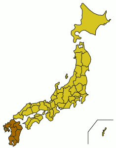
- English: A location map showing the location of Kyushu in relation to Japan.
- Latina: Charta geographica locum Ximi inter Iaponiam et eius provincias monstrans.
- Whence: From the English Wikipedia (Image:Japan kyushu map small.png), first uploaded by User:Synthetik.
Small map of Kyushu region
Map outline from public domain maps at http://aoki2.si.gunma-u.ac.jp/map/map.html

|
Shigenobu AOKI, the copyright holder of this work, allows anyone to use it for any purpose including unrestricted redistribution, commercial use, and modification.
|
Amlat ning simpan (File history)
Mag-click kang petsa/oras ba meng akit ing itsura ning simpan aniang panaun a ita.
| Petsa/Oras | Thumbnail | Sukad | Talagamit | Komentu/Puna | |
|---|---|---|---|---|---|
| salukuyan | 03:45, 5 Pebreru 2005 | | 235 × 300 (6 KB) | Muke | From the English Wikipedia, {{PD}} |
↓Suglung kareng simpan (''file links'')
Ing tutuking page links kaniting simpan (file):
Global file usage
The following other wikis use this file:
- Usage on af.wikipedia.org
- Usage on ar.wikipedia.org
- Usage on az.wikipedia.org
- Usage on ba.wikipedia.org
- Usage on be.wikipedia.org
- Usage on bg.wikipedia.org
- Usage on bn.wikipedia.org
- Usage on br.wikipedia.org
- Usage on ckb.wikipedia.org
- Usage on cs.wikipedia.org
- Usage on cy.wikipedia.org
- Usage on da.wikipedia.org
- Usage on de.wikipedia.org
- Usage on el.wikipedia.org
- Usage on en.wikinews.org
- Usage on es.wikipedia.org
- Usage on et.wikipedia.org
- Usage on fa.wikipedia.org
- Usage on fi.wiktionary.org
- Usage on fo.wikipedia.org
- Usage on frr.wikipedia.org
- Usage on fr.wikinews.org
- Usage on fr.wikivoyage.org
- Usage on fr.wiktionary.org
- Usage on gd.wikipedia.org
- Usage on gl.wikipedia.org
- Usage on hak.wikipedia.org
- Usage on ha.wikipedia.org
- Usage on he.wikipedia.org
- Usage on hi.wikipedia.org
- Usage on hr.wikipedia.org
- Usage on hu.wikipedia.org
- Usage on ilo.wikipedia.org
- Usage on is.wikipedia.org
- Usage on it.wikipedia.org
- Usage on it.wikivoyage.org
- Usage on ka.wikipedia.org
- Usage on kk.wikipedia.org
- Usage on la.wiktionary.org
- Usage on mk.wikipedia.org
- Usage on mr.wikipedia.org
View more global usage of this file.