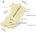
File:Main towns in the province of Castellón.png

Size of this preview: 665 × 600 pixels. Other resolutions: 266 × 240 pixels | 532 × 480 pixels | 852 × 768 pixels | 1,183 × 1,067 pixels.
Ing minunang simpan (file) (1,183 × 1,067 pixel, sukad ning simpan: 200 KB, MIME type: image/png)
Amlat ning simpan (File history)
Mag-click kang petsa/oras ba meng akit ing itsura ning simpan aniang panaun a ita.
| Petsa/Oras | Thumbnail | Sukad | Talagamit | Komentu/Puna | |
|---|---|---|---|---|---|
| salukuyan | 17:53, 25 Agostu 2006 |  | 1,183 × 1,067 (200 KB) | Rodriguillo | Map of the '''province of Castellón''' (eastern Spain). All the towns with a population larger than 7,000 (according to 2005 official INE census) are present in the map. Made by Rodriguillo thanks to [[Castellón_-_Mapa_municipal |
↓Suglung kareng simpan (''file links'')
Ing tutuking page links kaniting simpan (file):
Global file usage
The following other wikis use this file:
- Usage on el.wikipedia.org
- Usage on en.wikipedia.org
- Usage on fa.wikipedia.org
- Usage on he.wikipedia.org
- Usage on ja.wikipedia.org
- Usage on mk.wikipedia.org
- Usage on ms.wikipedia.org
- Usage on sco.wikipedia.org
- Usage on vi.wikipedia.org
- Usage on zh.wikipedia.org

