
File:Map AP dist all shaded.png
Size of this preview: 702 × 599 pixels. Other resolutions: 281 × 240 pixels | 562 × 480 pixels | 922 × 787 pixels.
Ing minunang simpan (file) (922 × 787 pixel, sukad ning simpan: 110 KB, MIME type: image/png)

|
This map image could be re-created using vector graphics as an SVG file. This has several advantages; see Commons:Media for cleanup for more information. If an SVG form of this image is available, please upload it and afterwards replace this template with
{{vector version available|new image name}}.
It is recommended to name the SVG file “Map AP dist all shaded.svg”—then the template Vector version available (or Vva) does not need the new image name parameter. |
Sampulung (summary)
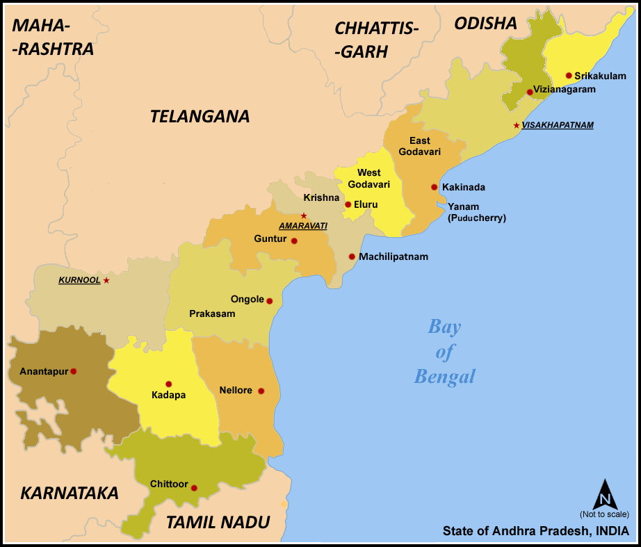
| Description | Map of w:Andhra Pradesh, India with district boundaries - add districts shaded. |
| Petsa | 7 Eneru 2006 (original upload date) |
| Pikuanan | No machine-readable source provided. Own work assumed (based on copyright claims). |
| Maki-akda | No machine-readable author provided. Miljoshi assumed (based on copyright claims). |
| Other versions | For updated version covering Reorganisation of Andhra Pradesh into Telangana and Andhra Pradesh File:Ap-districts.png |
Pamamie lisensia
I, the copyright holder of this work, hereby publish it under the following licenses:

|
Permission is granted to copy, distribute and/or modify this document under the terms of the GNU Free Documentation License, Version 1.2 or any later version published by the Free Software Foundation; with no Invariant Sections, no Front-Cover Texts, and no Back-Cover Texts. A copy of the license is included in the section entitled GNU Free Documentation License. |
| This file is licensed under the Creative Commons Attribution-Share Alike 3.0 Unported license. | ||
| ||
| This licensing tag was added to this file as part of the GFDL licensing update. |
This file is licensed under the Creative Commons Attribution-Share Alike 2.5 Generic, 2.0 Generic and 1.0 Generic license.
- You are free:
- to share – to copy, distribute and transmit the work
- to remix – to adapt the work
- Under the following conditions:
- attribution – You must give appropriate credit, provide a link to the license, and indicate if changes were made. You may do so in any reasonable manner, but not in any way that suggests the licensor endorses you or your use.
- share alike – If you remix, transform, or build upon the material, you must distribute your contributions under the same or compatible license as the original.
You may select the license of your choice.
Amlat ning simpan (File history)
Mag-click kang petsa/oras ba meng akit ing itsura ning simpan aniang panaun a ita.
| Petsa/Oras | Thumbnail | Sukad | Talagamit | Komentu/Puna | |
|---|---|---|---|---|---|
| salukuyan | 07:57, 8 Marsu 2021 | | 922 × 787 (110 KB) | Sbb1413 | Added the names of unnamed district HQs, plus the surrounding states. Removed the locator map as it (incorrectly) shows Aksai Chin as under the administration of India. |
| 07:15, 5 Marsu 2021 |  | 923 × 790 (105 KB) | Sbb1413 | Removed Hyderabad as capital, added Amaravati, Kurnool and Visakhapatnam as capitals. | |
| 11:20, 2 Juniu 2014 |  | 923 × 881 (83 KB) | Adityamadhav83 | map updated after bifurcation of Andhra Pradesh | |
| 12:19, 7 Eneru 2006 |  | 923 × 881 (63 KB) | Miljoshi | Map of w:Andhra Pradesh, India with district boundaries - add districts shaded. Category:Andhra Pradesh district maps |
↓Suglung kareng simpan (''file links'')
Ing tutuking 3 pages link kaniting simpan (file):
Global file usage
The following other wikis use this file:
- Usage on ast.wikipedia.org
- Usage on awa.wikipedia.org
- Usage on bn.wikipedia.org
- Usage on ca.wikipedia.org
- Usage on es.wikipedia.org
- Usage on fi.wikipedia.org
- Usage on frr.wikipedia.org
- Usage on fr.wikipedia.org
- Usage on gu.wikipedia.org
- Usage on hi.wikipedia.org
- Usage on hu.wikipedia.org
- Usage on id.wikipedia.org
- Usage on it.wikipedia.org
- Usage on ja.wikipedia.org
- Usage on kn.wikipedia.org
- Usage on ml.wikipedia.org
- Usage on nl.wikipedia.org
View more global usage of this file.