
File:Map of Alameda County 1878 LARGE.jpg

Ing minunang simpan (file) (960 × 611 pixel, sukad ning simpan: 496 KB, MIME type: image/jpeg)
Taken from en:
|
This work is in the public domain in its country of origin and other countries and areas where the copyright term is the author's life plus 70 years or fewer.
| |
| This file has been identified as being free of known restrictions under copyright law, including all related and neighboring rights. | |
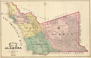
Author: Haynes, M.B.; Thompson & West Date: 1878 Short Title: Alameda County map Publisher: Oakland, Thompson and West Type: Atlas Map Scale:1: 126,720
Source: http://www.alamedainfo.com/alameda_1878.htm
Amlat ning simpan (File history)
Mag-click kang petsa/oras ba meng akit ing itsura ning simpan aniang panaun a ita.
| Petsa/Oras | Thumbnail | Sukad | Talagamit | Komentu/Puna | |
|---|---|---|---|---|---|
| salukuyan | 15:42, 12 Juliu 2005 | | 960 × 611 (496 KB) | Pyramide~commonswiki | Taken from en: {{pd}} '''Author:''' Haynes, M.B.; Thompson & West '''Date:''' 1878 '''Short Title:''' Alameda County map '''Publisher:''' Oakland, Thompson and West '''Type:''' Atlas Map '''Scale:'''1: 126,720 Source: http://www.alamedainfo.com/alameda_ |
↓Suglung kareng simpan (''file links'')
Ing tutuking page links kaniting simpan (file):
Global file usage
The following other wikis use this file:
- Usage on en.wikipedia.org
- Usage on fi.wikipedia.org
- Usage on fr.wikipedia.org
- Usage on hu.wikipedia.org
- Usage on id.wikipedia.org
- Usage on no.wikipedia.org
- Usage on ru.wikipedia.org