
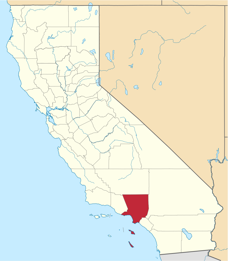
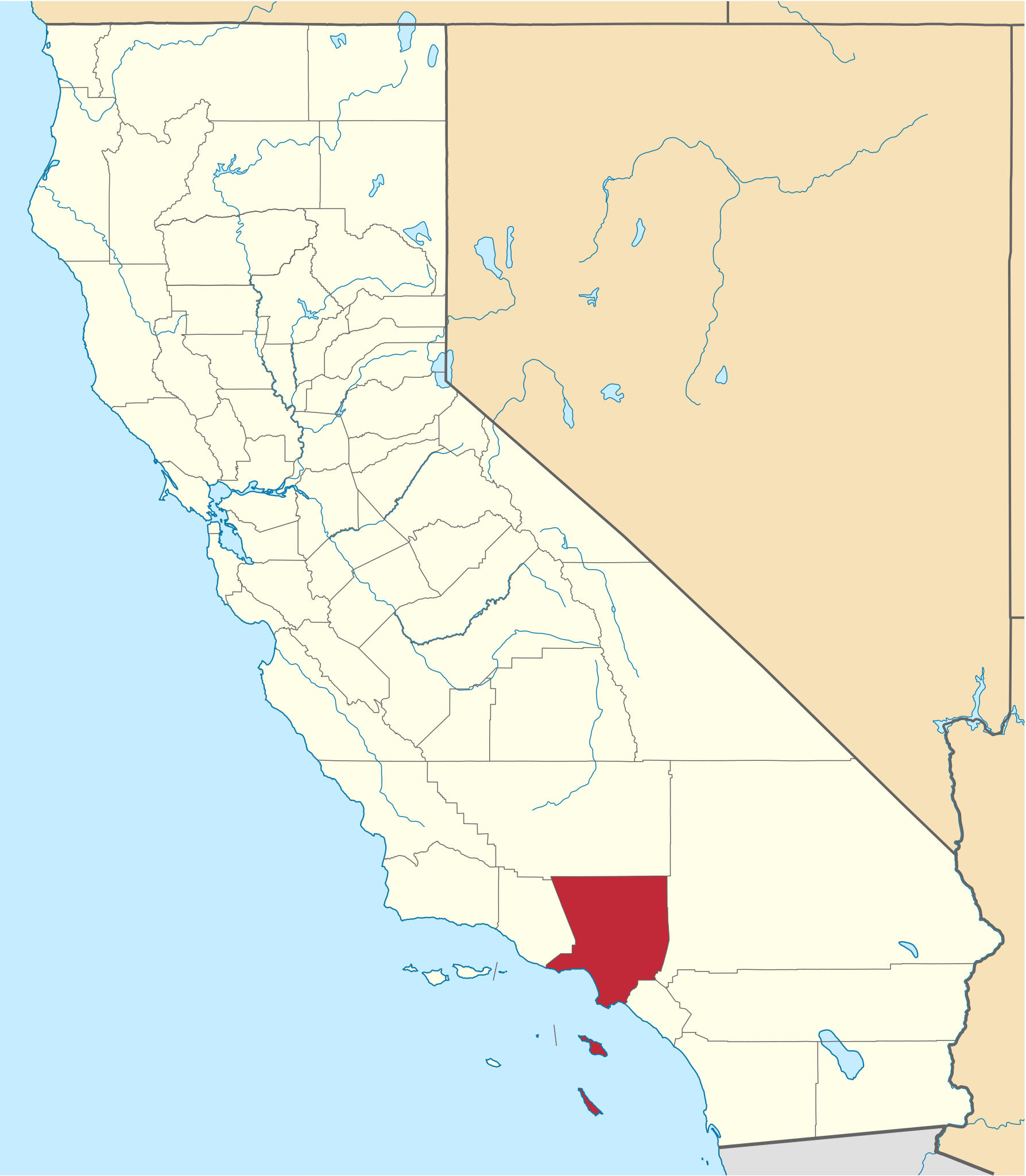
File:Map of California highlighting Los Angeles County.svg

Size of this PNG preview of this SVG file: 523 × 599 pixels. Other resolutions: 209 × 240 pixels | 419 × 480 pixels | 670 × 768 pixels | 894 × 1,024 pixels | 1,787 × 2,048 pixels | 1,022 × 1,171 pixels.
Ing minunang simpan (file) (SVG file, masasabing 1,022 × 1,171 pixels, dagul ning simpan: 488 KB)
Sampulung (summary)
| Description | |
| Petsa | |
| Pikuanan | nationalatlas.gov, specifically countyp020.tar.gz on the Raw Data Download page. The maps also use state outline data from statesp020.tar.gz. |
| Maki-akda | David Benbennick made this map. |
| Other versions | For more information, see Commons:United States county locator maps. |
| SVG genesis |
| I, the copyright holder of this work, release this work into the public domain. This applies worldwide. In some countries this may not be legally possible; if so: I grant anyone the right to use this work for any purpose, without any conditions, unless such conditions are required by law. |
Amlat ning simpan (File history)
Mag-click kang petsa/oras ba meng akit ing itsura ning simpan aniang panaun a ita.
| Petsa/Oras | Thumbnail | Sukad | Talagamit | Komentu/Puna | |
|---|---|---|---|---|---|
| salukuyan | 18:23, 25 Nobyembri 2016 | | 1,022 × 1,171 (488 KB) | Spartan7W | Update high quality map |
| 10:26, 12 Pebreru 2006 |  | 9,164 × 10,536 (229 KB) | David Benbennick | {{subst:User:Dbenbenn/clm|county=Los Angeles County|state=California}} |
↓Suglung kareng simpan (''file links'')
Ing tutuking 6 pages link kaniting simpan (file):
Global file usage
The following other wikis use this file:
- Usage on af.wikipedia.org
- Usage on ar.wikipedia.org
- لوس أنجلوس
- مقاطعة لوس أنجلوس (كاليفورنيا)
- سانتا مونيكا (كاليفورنيا)
- بيفرلي هيلز (كاليفورنيا)
- لونغ بيتش (كاليفورنيا)
- غلينديل (كاليفورنيا)
- أغورا هيلز (كاليفورنيا)
- بومونا (كاليفورنيا)
- إل سغوندو
- باراماونت (كاليفورنيا)
- ألهامبرا (كاليفورنيا)
- أركاديا (كاليفورنيا)
- أرتيسيا (كاليفورنيا)
- أفالون (كاليفورنيا)
- أزوسا (كاليفورنيا)
- بالدوين بارك (كاليفورنيا)
- بيل (كاليفورنيا)
- بيل غاردينس (كاليفورنيا)
- بيلفلاوير (كاليفورنيا)
- برادبوري (كاليفورنيا)
- بربانك (كاليفورنيا)
- كالاباساس (كاليفورنيا)
- كارسون (كاليفورنيا)
- سيرريتوس (كاليفورنيا)
- كلاريمونت (كاليفورنيا)
- سيتي أوف كوميرسي (كاليفورنيا)
- كومبتون (كاليفورنيا)
- كوفينا (كاليفورنيا)
- كوداهي (كاليفورنيا)
- كولفر سيتي
- دياموند بار (كاليفورنيا)
- داوني (كاليفورنيا)
- دوارتي (كاليفورنيا)
- إل مونتي (كاليفورنيا)
- غاردينا (كاليفورنيا)
- غليندورا (كاليفورنيا)
- هاوييان غاردينس (كاليفورنيا)
- هاوثورني (كاليفورنيا)
- هيرموسا بيتش (كاليفورنيا)
- هيدين هيلز (كاليفورنيا)
- هونتينغتون بارك (كاليفورنيا)
- سيتي أوف إندوستري (كاليفورنيا)
- إنغليووود (كاليفورنيا)
- إرويندالي (كاليفورنيا)
- لا كانيادا فلينتريدج (كاليفورنيا)
- لا هابرا هيايتس (كاليفورنيا)
- لا ميرادا (كاليفورنيا)
- لا بوينتي (كاليفورنيا)
- لا فيرني (كاليفورنيا)
View more global usage of this file.