
File:Map of Hawaii NA.png
Size of this preview: 776 × 600 pixels. Other resolutions: 311 × 240 pixels | 621 × 480 pixels | 994 × 768 pixels | 1,280 × 989 pixels | 2,122 × 1,640 pixels.
Ing minunang simpan (file) (2,122 × 1,640 pixel, sukad ning simpan: 370 KB, MIME type: image/png)
Sampulung (summary)
| Description |
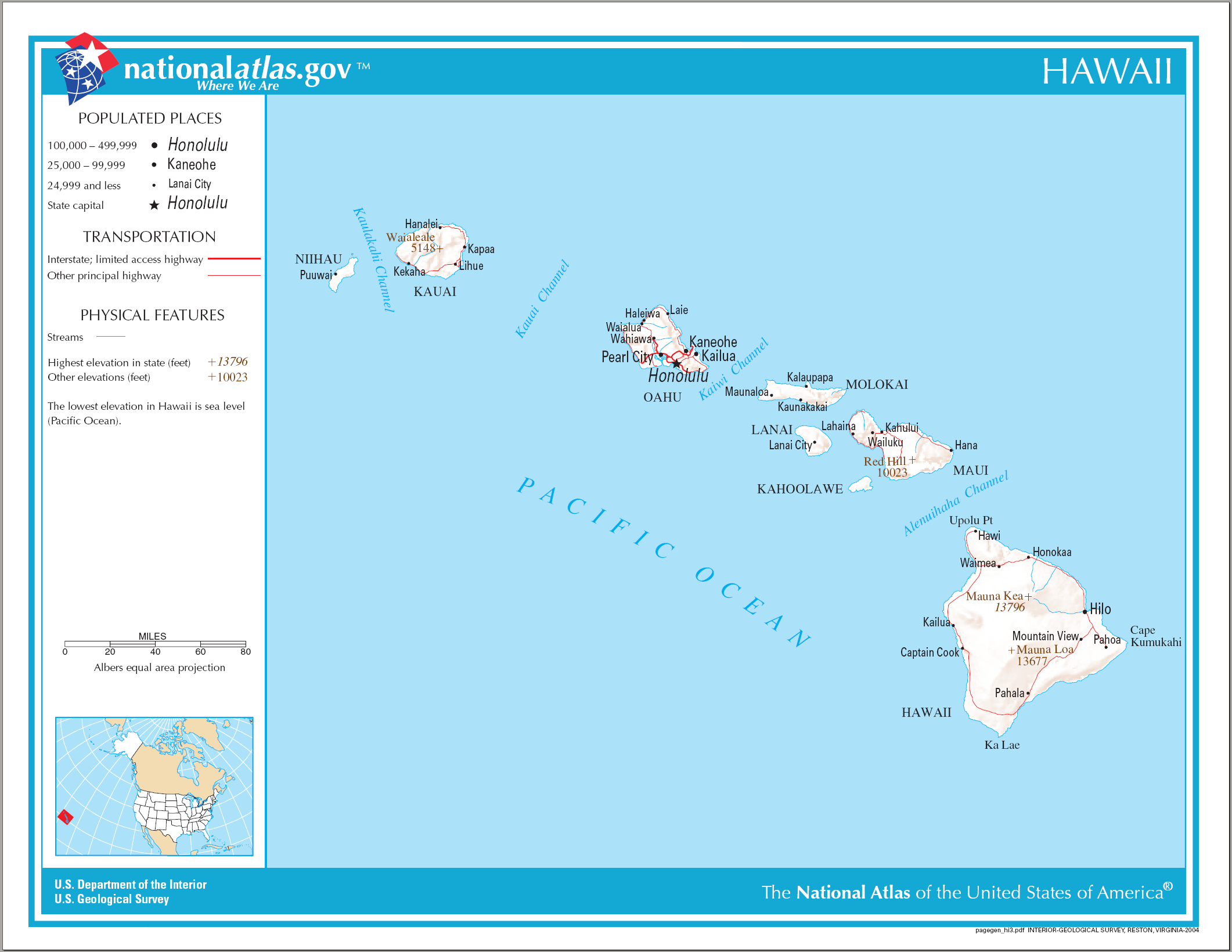
English: Reference Map of Hawaii. |
| Petsa | |
| Pikuanan | |
| Maki-akda | National Atlas of the United States |
| Permission (Reusing this file) |
Public domain |
Pamamie lisensia
This map was obtained from an edition of the National Atlas of the United States. Like almost all works of the U.S. federal government, works from the National Atlas are in the public domain in the United States.
Online access: NationalAtlas.gov | 1970 print edition: Library of Congress, Perry-Castañeda Library
|
Amlat ning simpan (File history)
Mag-click kang petsa/oras ba meng akit ing itsura ning simpan aniang panaun a ita.
| Petsa/Oras | Thumbnail | Sukad | Talagamit | Komentu/Puna | |
|---|---|---|---|---|---|
| salukuyan | 10:26, 15 Agostu 2006 | | 2,122 × 1,640 (370 KB) | Huebi~commonswiki | {{Information| |Description=Map of Hawaii |Source=[http://www.nationalatlas.gov National Atlas] }} Category:Maps of the United States Category:Maps of Hawaii {{PD-USGov-Atlas}} |
↓Suglung kareng simpan (''file links'')
Ing tutuking page links kaniting simpan (file):
Global file usage
The following other wikis use this file:
- Usage on af.wikipedia.org
- Usage on als.wikipedia.org
- Usage on cs.wikipedia.org
- Usage on da.wikipedia.org
- Usage on de.wikipedia.org
- Usage on en.wikipedia.org
- Usage on es.wikipedia.org
- Usage on fa.wikipedia.org
- Usage on he.wikipedia.org
- Usage on hr.wikipedia.org
- Usage on hr.wiktionary.org
- Usage on hsb.wikipedia.org
- Usage on hu.wikipedia.org
- Usage on incubator.wikimedia.org
- Usage on it.wikipedia.org
- Usage on kn.wikipedia.org
- Usage on ko.wikipedia.org
- Usage on mk.wikipedia.org
- Usage on ml.wikipedia.org
- Usage on nl.wikipedia.org
- Usage on pdc.wikipedia.org
- Usage on pl.wikipedia.org
- Usage on pt.wikipedia.org
- Usage on ru.wikivoyage.org
- Usage on sh.wikipedia.org
- Usage on sr.wikipedia.org
- Usage on sv.wikipedia.org
- Usage on sw.wikipedia.org
- Usage on te.wikipedia.org
- Usage on zea.wikipedia.org