
File:Mapa administrativo de Chile.png

Size of this preview: 366 × 598 pixels. Other resolutions: 147 × 240 pixels | 293 × 480 pixels | 896 × 1,465 pixels.
Ing minunang simpan (file) (896 × 1,465 pixel, sukad ning simpan: 181 KB, MIME type: image/png)

|
This image (or all images in this category) uses inside labels or attached captions in a specific script or language and should be converted to a language neutral form. This would allow its use in all Wikimedia projects and, more importantly, all Wikimedia languages.
|
| Description |
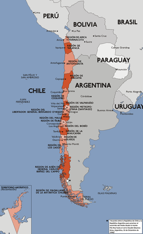
Español: Mapa con la división administrativa de la República de Chile.
Deutsch: Darstellung zeigt die Verwaltungsgliederung von Chile.
English: This diagram shows the administrative districts of Chile.
Français : Ce diagramme montre les districts administratifs du Chili. |
||||||||
| Petsa | |||||||||
| Pikuanan | Karte chile verwaltungsgliederung.png | ||||||||
| Maki-akda | Sansculotte (original), B1mbo | ||||||||
| Permission (Reusing this file) |
|

Amlat ning simpan (File history)
Mag-click kang petsa/oras ba meng akit ing itsura ning simpan aniang panaun a ita.
| Petsa/Oras | Thumbnail | Sukad | Talagamit | Komentu/Puna | |
|---|---|---|---|---|---|
| salukuyan | 17:56, 22 Pebreru 2018 | | 896 × 1,465 (181 KB) | Janitoalevic | . |
| 17:34, 22 Pebreru 2018 |  | 896 × 1,465 (181 KB) | Janitoalevic | Added Ñuble Region | |
| 18:33, 2 Disyembri 2017 |  | 896 × 1,465 (171 KB) | Janitoalevic | Fixed borders | |
| 22:47, 22 Juliu 2011 |  | 896 × 1,465 (150 KB) | Ras67 | cropped | |
| 18:40, 9 Pebreru 2008 |  | 900 × 1,469 (209 KB) | Jorge | Corregí ortografía {{Convert to international}} {{es|Mapa con la división administrativa (1979 - 2006) de la República de Chile. Este mapa está traducido al español en base a Image:Karte chile verwaltungsgliederung.png, crea | |
| 03:28, 3 Oktubri 2007 |  | 900 × 1,469 (237 KB) | B1mbo | Agregando nuevas regiones | |
| 22:29, 28 Oktubri 2006 |  | 900 × 1,469 (231 KB) | B1mbo | ||
| 22:07, 28 Oktubri 2006 |  | 900 × 1,469 (231 KB) | B1mbo | Agregado el Territorio Antártico (reclamación) | |
| 17:33, 4 Setyembri 2006 |  | 900 × 1,469 (267 KB) | Gonzaloluengo | ||
| 22:35, 25 Eneru 2006 |  | 900 × 1,469 (190 KB) | B1mbo | de:Bild:Karte chile verwaltungsgliederung.png {{Spanish}} Mapa con la división administrativa (1979 - 2006) de la República de Chile. Este mapa está traducido al español en base a Image:Karte chile verwaltungsgliederung.png, |
↓Suglung kareng simpan (''file links'')
Ing tutuking page links kaniting simpan (file):
Global file usage
The following other wikis use this file:
- Usage on ace.wikipedia.org
- Usage on af.wikipedia.org
- Usage on an.wikipedia.org
- Usage on awa.wikipedia.org
- Usage on ay.wikipedia.org
- Usage on azb.wikipedia.org
- Usage on bat-smg.wikipedia.org
- Usage on bcl.wikipedia.org
- Usage on bh.wikipedia.org
- Usage on bi.wikipedia.org
- Usage on bpy.wikipedia.org
- Usage on bs.wikipedia.org
- Usage on cbk-zam.wikipedia.org
- Usage on ceb.wikipedia.org
- Usage on ch.wikipedia.org
- Usage on crh.wikipedia.org
- Usage on cv.wikipedia.org
- Usage on de.wikipedia.org
- Usage on diq.wikipedia.org
- Usage on dsb.wikipedia.org
- Usage on ee.wikipedia.org
- Usage on el.wikipedia.org
- Usage on en.wikibooks.org
- Usage on eo.wikipedia.org
- Usage on es.wikipedia.org
- Anexo:Puntos extremos de Chile
- Anexo:Gentilicios de Chile
- Anexo:Regiones de Chile por superficie
- Anexo:Especies de coníferas nativas de Chile
- Anexo:Sitios relevantes para la observación de aves en Chile
- Usuario:Sgonzalezb/Reyno de Chile
- Anexo:Regiones de Chile por población
- Anexo:Vertebrados introducidos en Chile
- Vertebrados introducidos en Chile
- Anexo:Regiones de Chile por densidad
- Usage on es.wikibooks.org
- Usage on eu.wikipedia.org
- Usage on fiu-vro.wikipedia.org
- Usage on frp.wikipedia.org
- Usage on fur.wikipedia.org
- Usage on fy.wikipedia.org
- Usage on ga.wikipedia.org
- Usage on gd.wikipedia.org
- Usage on got.wikipedia.org
- Usage on gu.wikipedia.org
- Usage on hr.wikipedia.org
- Usage on hu.wikipedia.org
- Usage on id.wikipedia.org
View more global usage of this file.