
File:NusaTenggara.png
Ala nang mas malino pa.
NusaTenggara.png (400 × 163 pixel, sukad ning simpan: 27 KB, MIME type: image/png)
| Description |
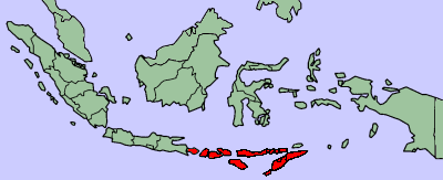
Map showing the Lesser Sunda Islands (Nusa Tenggara) Deutsch: Karte der Kleinen Sundainseln
Español: Mapa de las islas menores de la Sonda.
Français : Les Petites Îles de la Sonde |
| Pikuanan |
Original image from |
| Maki-akda | last edit by J. Patrick Fischer |
| Permission (Reusing this file) |
like original image GFDL |
| Other versions | [1] |
![[1]](http://wikitravel.org/en/Image:IndonesiaNusaTenggara.png)

|
Permission is granted to copy, distribute and/or modify this document under the terms of the GNU Free Documentation License, Version 1.2 or any later version published by the Free Software Foundation; with no Invariant Sections, no Front-Cover Texts, and no Back-Cover Texts. A copy of the license is included in the section entitled GNU Free Documentation License. |
| This file is licensed under the Creative Commons Attribution-Share Alike 3.0 Unported license. | ||
| ||
| This licensing tag was added to this file as part of the GFDL licensing update. |
Amlat ning simpan (File history)
Mag-click kang petsa/oras ba meng akit ing itsura ning simpan aniang panaun a ita.
| Petsa/Oras | Thumbnail | Sukad | Talagamit | Komentu/Puna | |
|---|---|---|---|---|---|
| salukuyan | 20:24, 22 Abril 2017 | 400 × 163 (27 KB) | J. Patrick Fischer | Reverted [http://msi.nga.mil/MSISiteContent/StaticFiles/NAV_PUBS/SD/Pub163/Pub163bk.pdf] | |
| 00:02, 14 Nobyembri 2013 |  | 391 × 352 (9 KB) | Fobos92 | . | |
| 03:29, 12 Abril 2013 |  | 2,000 × 938 (180 KB) | Afrogindahood | Added the Barat Daya Islands and Tanimbar Islands of Maluku province, which is geographically still part of the Lesser Sunda Islands. | |
| 10:20, 13 Agostu 2006 | 400 × 163 (27 KB) | J. Patrick Fischer | {{Information |Description=Map showing the Lesser Sunda Islands (''Nusa Tenggara'') |Source=Original image from [http://wikitravel.org/en/Image:IndonesiaNusaTenggara.png] |Date= |Author=last edit by J. Patrick Fischer |Permission=like original image GFDL | ||
| 00:28, 4 Oktubri 2005 | 400 × 163 (32 KB) | *drew~commonswiki | Map showing the Lesser Sunda Islands (''Nusa Tenggara'') From: [http://wikitravel.org/en/Image:IndonesiaNusaTenggara.png] {{GFDL}} Category:Indonesian islands |
↓Suglung kareng simpan (''file links'')
Ing tutuking page links kaniting simpan (file):
Global file usage
The following other wikis use this file:
- Usage on ar.wikipedia.org
- Usage on ast.wikipedia.org
- Usage on az.wikipedia.org
- Usage on ba.wikipedia.org
- Usage on br.wikipedia.org
- Usage on bs.wikipedia.org
- Usage on ca.wikipedia.org
- Usage on ceb.wikipedia.org
- Usage on cs.wikipedia.org
- Usage on cy.wikipedia.org
- Usage on da.wikipedia.org
- Usage on de.wikipedia.org
- Usage on de.wikivoyage.org
- Usage on el.wikipedia.org
- Usage on en.wikipedia.org
- Usage on eo.wikipedia.org
- Usage on es.wikipedia.org
- Usage on et.wikipedia.org
- Usage on eu.wikipedia.org
- Usage on fi.wikipedia.org
- Usage on fr.wikipedia.org
- Usage on fy.wikipedia.org
- Usage on gl.wikipedia.org
- Usage on hak.wikipedia.org
- Usage on hi.wikipedia.org
- Usage on hr.wikipedia.org
- Usage on hsb.wikipedia.org
- Usage on hu.wikipedia.org
- Usage on id.wikipedia.org
- Usage on id.wiktionary.org
- Usage on is.wikipedia.org
- Usage on it.wikipedia.org
- Usage on it.wikivoyage.org
- Usage on ja.wikipedia.org
- Usage on ka.wikipedia.org
- Usage on ko.wikipedia.org
- Usage on lt.wikipedia.org
- Usage on map-bms.wikipedia.org
- Usage on mk.wikipedia.org
- Usage on ml.wikipedia.org
- Usage on mn.wikipedia.org
- Usage on mrj.wikipedia.org
View more global usage of this file.