
File:Ph Bangsamoro Autonomous Region.png

Size of this preview: 800 × 455 pixels. Other resolutions: 320 × 182 pixels | 640 × 364 pixels | 1,024 × 582 pixels | 1,280 × 727 pixels | 2,560 × 1,454 pixels | 3,654 × 2,076 pixels.
Ing minunang simpan (file) (3,654 × 2,076 pixel, sukad ning simpan: 703 KB, MIME type: image/png)
Sampulung (summary)
| Description |
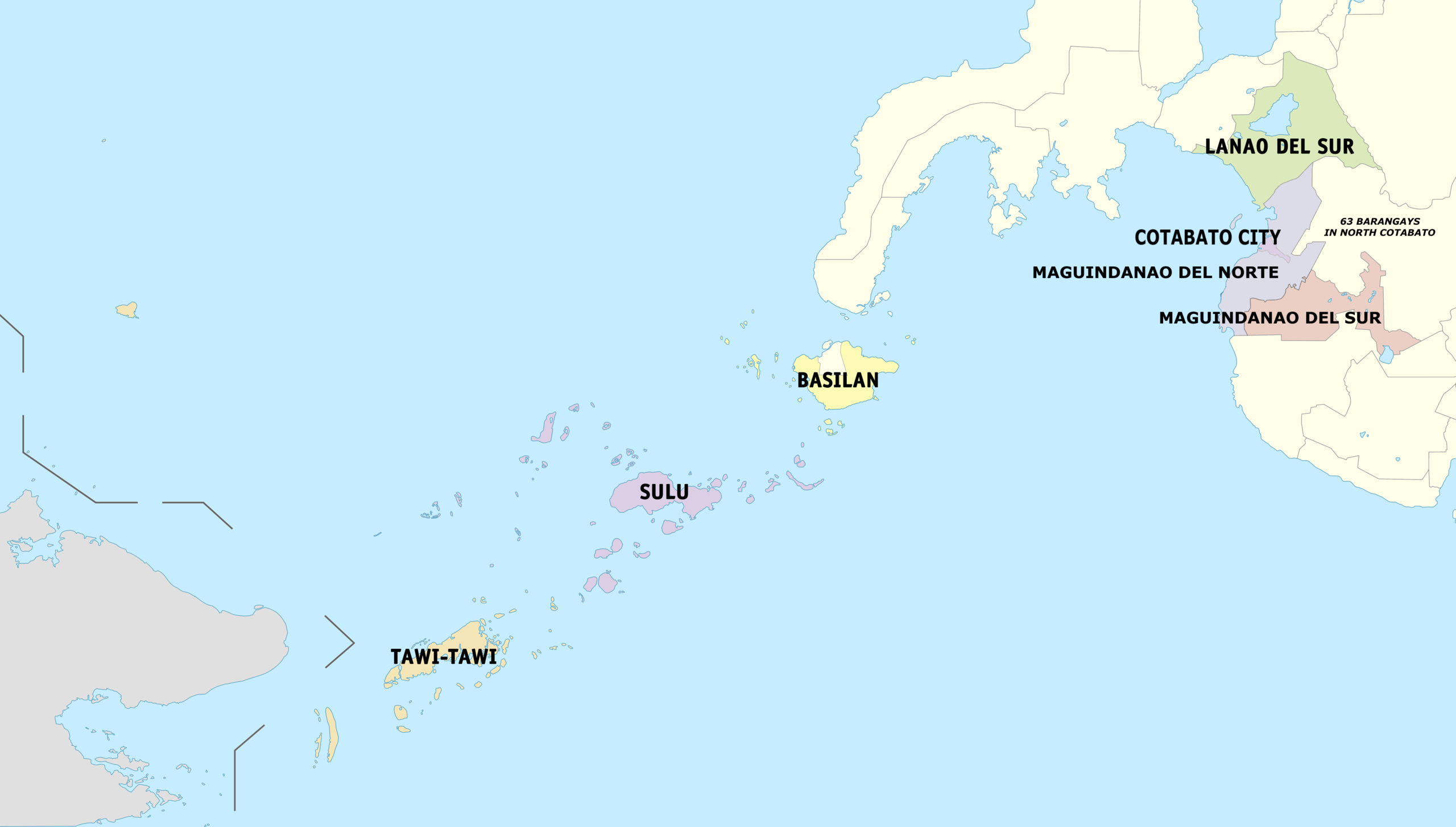
English: Political map of the Bangsamoro Autonomous Region in Muslim Mindanao. |
| Petsa | |
| Pikuanan | Own work |
| Maki-akda | Hariboneagle927 |

|
File:Map of Bangsamoro (local government units).svg is a vector version of this file. It should be used in place of this PNG file when not inferior.
File:Ph Bangsamoro Autonomous Region.png → File:Map of Bangsamoro (local government units).svg
For more information, see Help:SVG. |
.svg) |
Pamamie lisensia
I, the copyright holder of this work, hereby publish it under the following license:
This file is licensed under the Creative Commons Attribution-Share Alike 3.0 Unported license.
- You are free:
- to share – to copy, distribute and transmit the work
- to remix – to adapt the work
- Under the following conditions:
- attribution – You must give appropriate credit, provide a link to the license, and indicate if changes were made. You may do so in any reasonable manner, but not in any way that suggests the licensor endorses you or your use.
- share alike – If you remix, transform, or build upon the material, you must distribute your contributions under the same or compatible license as the original.
Amlat ning simpan (File history)
Mag-click kang petsa/oras ba meng akit ing itsura ning simpan aniang panaun a ita.
| Petsa/Oras | Thumbnail | Sukad | Talagamit | Komentu/Puna | |
|---|---|---|---|---|---|
| salukuyan | 05:51, 18 Setyembri 2022 | | 3,654 × 2,076 (703 KB) | Maanshen | Due to the succesion of the 2022 Maguindanao division plebiscite, The province of Maguindanao is divided into two provinces |
| 08:36, 26 Nobyembri 2021 |  | 3,654 × 2,076 (629 KB) | Nissan2020 | Reverted to version as of 01:13, 18 February 2019 (UTC) | |
| 03:49, 26 Nobyembri 2021 |  | 4,000 × 2,056 (535 KB) | Nissan2020 | Reverted to version as of 11:39, 28 March 2021 (UTC) | |
| 08:56, 30 Marsu 2021 |  | 3,654 × 2,076 (629 KB) | HueMan1 | Reverted to version as of 15:32, 14 May 2020 (UTC) | |
| 11:39, 28 Marsu 2021 |  | 4,000 × 2,056 (535 KB) | Teamayuiyui | Update from 2021 | |
| 15:32, 14 Mayu 2020 |  | 3,654 × 2,076 (629 KB) | HueMan1 | Reverted to version as of 01:13, 18 February 2019 (UTC) | |
| 01:13, 18 Pebreru 2019 |  | 3,654 × 2,076 (629 KB) | Hariboneagle927 | Plus 63 barangays in North Cotabato. Can't find an accurate barangay maps at the moment. And this is just a provisional edit. | |
| 12:09, 26 Eneru 2019 |  | 3,654 × 2,076 (621 KB) | Hariboneagle927 | User created page with UploadWizard |
↓Suglung kareng simpan (''file links'')
Ing tutuking page links kaniting simpan (file):
Global file usage
The following other wikis use this file:
- Usage on bcl.wikipedia.org
- Usage on bn.wikipedia.org
- Usage on cbk-zam.wikipedia.org
- Usage on ceb.wikipedia.org
- Usage on el.wikipedia.org
- Usage on fa.wikipedia.org
- Usage on fr.wikipedia.org
- Usage on ms.wikipedia.org
- Usage on tl.wikipedia.org
- Usage on war.wikipedia.org