
File:Platslc.jpg
Size of this preview: 378 × 599 pixels. Other resolutions: 151 × 240 pixels | 579 × 917 pixels.
Ing minunang simpan (file) (579 × 917 pixel, sukad ning simpan: 582 KB, MIME type: image/jpeg)
Sampulung (summary)
| Description |
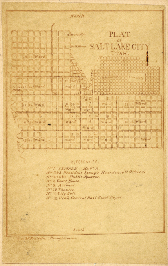
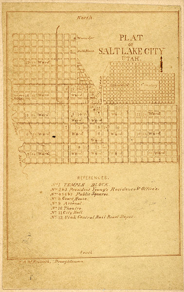
English: Photograph of a street map of Salt Lake City called Plat of Salt Lake City, Utah. A street map, showing the blocks and divisions of blocks in the downtown Salt Lake City area produced in the late 1860's by E. Martin, Photographer, East Temple Street, Salt Lake City, Utah Territory. |
| Petsa | circa 1860 |
| Pikuanan | From Library of Congress [1]. Courtesy Special Collections, Harold B. Lee Library, Brigham Young University, Provo, UT 84602. |
| Maki-akda | E. Martin, Photographer, East Temple Street, Salt Lake City, Utah Territory. |
Pamamie lisensia
This media file is in the public domain in the United States. This applies to U.S. works where the copyright has expired, often because its first publication occurred prior to January 1, 1929, and if not then due to lack of notice or renewal. See this page for further explanation.
|
 | |
 |
This image might not be in the public domain outside of the United States; this especially applies in the countries and areas that do not apply the rule of the shorter term for US works, such as Canada, Mainland China (not Hong Kong or Macao), Germany, Mexico, and Switzerland. The creator and year of publication are essential information and must be provided. See Wikipedia:Public domain and Wikipedia:Copyrights for more details.
|
Original upload log
Transferred from en.wikipedia to Commons using For the Common Good.
The original description page was here. All following user names refer to en.wikipedia.
| Petsa/Oras | Sukad | Talagamit | Komentu/Puna |
|---|---|---|---|
| 15:07, 25 August 2014 | 579 × 917 (595,599 bytes) | w:en:Fallschirmjäger (talamitam | ambag) | Cropped |
| 01:51, 26 December 2004 | 645 × 1,076 (735,574 bytes) | w:en:JonMoore (talamitam | ambag) | {{PD-US}} From LOC. Courtesy Special Collections, Harold B. Lee Library, Brigham Young University, Provo, UT 84602. Photograph of a street map of Salt Lake City called Plat of Salt Lake City, Utah. A street map, showing the blocks and divisions of blocks |
Amlat ning simpan (File history)
Mag-click kang petsa/oras ba meng akit ing itsura ning simpan aniang panaun a ita.
| Petsa/Oras | Thumbnail | Sukad | Talagamit | Komentu/Puna | |
|---|---|---|---|---|---|
| salukuyan | 23:37, 1 Setyembri 2014 | | 579 × 917 (582 KB) | OgreBot | (BOT): Reverting to most recent version before archival |
| 23:37, 1 Setyembri 2014 |  | 645 × 1,076 (718 KB) | OgreBot | (BOT): Uploading old version of file from en.wikipedia; originally uploaded on 2004-12-26 01:51:15 by JonMoore | |
| 15:08, 25 Agostu 2014 |  | 579 × 917 (582 KB) | Liandrei | Transferred from en.wikipedia: see original upload log above |
↓Suglung kareng simpan (''file links'')
Ing tutuking page links kaniting simpan (file):
Global file usage
The following other wikis use this file:
- Usage on en.wikipedia.org
- Usage on ja.wikipedia.org