
File:Sulawesi map.PNG

Size of this preview: 543 × 599 pixels. Other resolutions: 217 × 240 pixels | 435 × 480 pixels | 696 × 768 pixels | 928 × 1,024 pixels | 1,492 × 1,647 pixels.
Ing minunang simpan (file) (1,492 × 1,647 pixel, sukad ning simpan: 83 KB, MIME type: image/png)
Sampulung (summary)
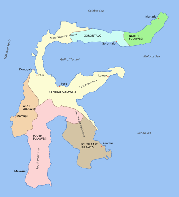
Sulawesi showing provinces, their capital cities, a few other cities and some surrounding areas of water. Note that there are other islands in this area which are not shown as this is a map of Sulawesi island itself.
For a blank map see Image:Sulawesi blank.PNG
derivative works
Derivative works of this file: Sulawesi map id.png
Pamamie lisensia

|
Permission is granted to copy, distribute and/or modify this document under the terms of the GNU Free Documentation License, Version 1.2 or any later version published by the Free Software Foundation; with no Invariant Sections, no Front-Cover Texts, and no Back-Cover Texts. A copy of the license is included in the section entitled GNU Free Documentation License. |
| This file is licensed under the Creative Commons Attribution-Share Alike 3.0 Unported license. | ||
| ||
| This licensing tag was added to this file as part of the GFDL licensing update. |
Amlat ning simpan (File history)
Mag-click kang petsa/oras ba meng akit ing itsura ning simpan aniang panaun a ita.
| Petsa/Oras | Thumbnail | Sukad | Talagamit | Komentu/Puna | |
|---|---|---|---|---|---|
| salukuyan | 12:11, 11 Marsu 2006 | | 1,492 × 1,647 (83 KB) | Roke~commonswiki | fixed borders of provinces |
| 04:55, 11 Marsu 2006 |  | 1,492 × 1,647 (82 KB) | Roke~commonswiki | Sulawesi showing provinces, their capital cities, a few other cities and some surrounding areas of water. Note that there are other islands in this area which are not shown as this is a map of Sulawesi island itself. Category:Sulawesi [[Category:Maps |
↓Suglung kareng simpan (''file links'')
Ing tutuking page links kaniting simpan (file):
Global file usage
The following other wikis use this file:
- Usage on af.wikipedia.org
- Usage on bg.wikipedia.org
- Usage on bn.wikipedia.org
- Usage on bug.wikipedia.org
- Usage on ca.wikipedia.org
- Usage on ceb.wikipedia.org
- Usage on cs.wikipedia.org
- Usage on cy.wikipedia.org
- Usage on el.wikipedia.org
- Usage on en.wikipedia.org
- Usage on es.wikipedia.org
- Usage on eu.wikipedia.org
- Usage on fa.wikipedia.org
- Usage on fi.wikipedia.org
- Usage on fr.wikipedia.org
- Usage on ga.wikipedia.org
- Usage on gl.wikipedia.org
- Usage on gl.wiktionary.org
- Usage on hi.wikipedia.org
- Usage on hu.wikipedia.org
- Usage on id.wiktionary.org
- Usage on ilo.wikipedia.org
- Usage on is.wikipedia.org
- Usage on it.wikipedia.org
- Usage on ja.wikipedia.org
- Usage on kk.wikipedia.org
- Usage on km.wikipedia.org
- Usage on la.wikipedia.org
- Usage on map-bms.wikipedia.org
- Usage on mi.wikipedia.org
- Usage on ml.wikipedia.org
- Usage on mrj.wikipedia.org
View more global usage of this file.