
File:Wyoming counties map.png

Size of this preview: 763 × 600 pixels. Other resolutions: 305 × 240 pixels | 611 × 480 pixels | 865 × 680 pixels.
Ing minunang simpan (file) (865 × 680 pixel, sukad ning simpan: 48 KB, MIME type: image/png)
Sampulung (summary)
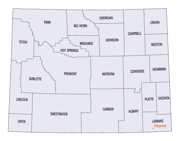
| Description | Map of Wyoming (USA), showing county names and boundary lines. |
| Petsa | |
| Pikuanan | Reference map: USGS county-map reference image (from US Government website): http://wy.water.usgs.gov/pubs/statebiblio/bibliomap.JPG. |
| Maki-akda | JosN |

|
This map image could be re-created using vector graphics as an SVG file. This has several advantages; see Commons:Media for cleanup for more information. If an SVG form of this image is available, please upload it and afterwards replace this template with
{{vector version available|new image name}}.
It is recommended to name the SVG file “Wyoming counties map.svg”—then the template Vector version available (or Vva) does not need the new image name parameter. |
Usage
The map has been labeled with typical lettering, but is only barely readable when displayed at medium thumbnail sizes. The map could be displayed in various thumbnail sizes, such as widths of either 250px or 300px, as follows:

Pamamie lisensia
| This file is licensed under the Creative Commons Attribution-Share Alike 3.0 Unported license. Subject to disclaimers. | ||
| ||
| This licensing tag was added to this file as part of the GFDL licensing update. |

|
Permission is granted to copy, distribute and/or modify this document under the terms of the GNU Free Documentation License, Version 1.2 or any later version published by the Free Software Foundation; with no Invariant Sections, no Front-Cover Texts, and no Back-Cover Texts. A copy of the license is included in the section entitled GNU Free Documentation License. Subject to disclaimers. |
Amlat ning simpan (File history)
Mag-click kang petsa/oras ba meng akit ing itsura ning simpan aniang panaun a ita.
| Petsa/Oras | Thumbnail | Sukad | Talagamit | Komentu/Puna | |
|---|---|---|---|---|---|
| salukuyan | 22:00, 16 Oktubri 2006 | | 865 × 680 (48 KB) | JosN | Map of Wyoming counties. |
↓Suglung kareng simpan (''file links'')
Ing tutuking page links kaniting simpan (file):
Global file usage
The following other wikis use this file:
- Usage on bs.wikipedia.org
- Usage on cs.wikipedia.org
- Usage on en.wikipedia.org
- Wyoming
- National Register of Historic Places listings in Wyoming
- Geography of Wyoming
- Index of Wyoming-related articles
- Outline of Wyoming
- Wikipedia:Village pump (technical)/Archive 162
- Wikipedia:Today's featured list/November 2021
- Portal:Wyoming
- Wikipedia:Today's featured list/November 22, 2021
- Wikipedia:Main Page history/2021 November 22
- Wikipedia:Main Page history/2021 November 22b
- Usage on fi.wikipedia.org
- Usage on fr.wikipedia.org
- Usage on he.wikipedia.org
- Usage on it.wikipedia.org
- Usage on ja.wikipedia.org
- Usage on ko.wikipedia.org
- Usage on nds.wikipedia.org
- Usage on nl.wikipedia.org
- Usage on no.wikipedia.org
- Usage on pl.wikipedia.org
- Usage on sq.wikipedia.org
- Usage on sv.wikipedia.org
- Usage on tr.wikipedia.org
- Usage on zh.wikipedia.org