Arkansas
- Ing artikulung iti tungkul ya keng the U.S. State. Para kareng aliwang kabaldugan na niti, Arkansas (disambiguation).
| |||||||||
| Peka Amanu | English | ||||||||
| Tungku Pekamaragul a Lakanbalen |
Little Rock Little Rock | ||||||||
| Lapad - Eganagana - Lapad - Kaba - % danum - Latitude - Longitude |
Ranku 29th 53,179 sq mi 137 732 km² 239 milya 385 km 261 milya 420 km 2.09 33°N to 36°30'N 89°41'W to 94°42'W | ||||||||
| Populasyun - Total (2000) - Pangasiksik |
Ranku 33rd 2,673,400 51.34/sq. mi 19.82/km² (34th) | ||||||||
| Elevation - Pekamatas a lugal - Kaustuan - Pekamababang Lugal |
2753 pie 839 m 650 pie 198 m 56 pie 17 m | ||||||||
| Pangatanggap keng Union | June 15, 1836 (25th) | ||||||||
| Gobernador Deng U.S. Senators |
Mike Huckabee (R) Blanche Lincoln (D) Mark Pryor (D) | ||||||||
| Oras zona | Central: UTC-6/DST-5 | ||||||||
| Abbreviations | AR Ark. US-AR | ||||||||
| Web site | www.arkansas.gov | ||||||||
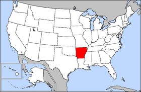
Ing Arkansas (/ˈɑrkənsɔː/ ; ar-kən-saw)[1] metung yang state atiu king mauling labuad na ning United States. Ing Arkansas kasepu na la deng anam a states, nung nu ing kayang aslagan sepu iyapin ing Ilug Mississippi.
Demographicu[mag-edit | alilan ya ing pikuwanan]
| Historical populations | |||
|---|---|---|---|
| Census | Pop. | %± | |
| 1810 | 1,062 | ||
| 1820 | 14,273 | 1,244% | |
| 1830 | 30,388 | 112.9% | |
| 1840 | 97,574 | 221.1% | |
| 1850 | 209,897 | 115.1% | |
| 1860 | 435,450 | 107.5% | |
| 1870 | 484,471 | 11.3% | |
| 1880 | 802,525 | 65.6% | |
| 1890 | 1,128,211 | 40.6% | |
| 1900 | 1,311,564 | 16.3% | |
| 1910 | 1,574,449 | 20% | |
| 1920 | 1,752,204 | 11.3% | |
| 1930 | 1,854,482 | 5.8% | |
| 1940 | 1,949,387 | 5.1% | |
| 1950 | 1,909,511 | −2% | |
| 1960 | 1,786,272 | −6.5% | |
| 1970 | 1,923,295 | 7.7% | |
| 1980 | 2,286,435 | 18.9% | |
| 1990 | 2,350,725 | 2.8% | |
| 2000 | 2,673,400 | 13.7% | |
| Est. 2008[2] | 2,855,390 | ||
Maulagang lakanbalen at balen[mag-edit | alilan ya ing pikuwanan]


Ding lagiung makapasala atin lang populasiun a maiggit a 20,000.
| Bulan-bulan a Pangkaraniwan a Matas ampong Mababang Temperatura para kareng Miyaliwang Lakanbalen ning Arkansas | ||||||||||||
| Lakanbalen | Ene | Peb | Mar | Abr | May | Jun | Jul | Ago | Sep | Oct | Nob | Dis |
|---|---|---|---|---|---|---|---|---|---|---|---|---|
| Fort Smith | 48/28 | 55/33 | 64/41 | 73/49 | 80/59 | 88/67 | 93/71 | 93/70 | 85/63 | 75/50 | 61/40 | 51/31 |
| Little Rock | 50/31 | 56/35 | 64/43 | 73/50 | 81/59 | 89/68 | 93/72 | 92/70 | 85/64 | 75/52 | 62/42 | 52/34 |
| [3] | ||||||||||||
Suglung Palwal[mag-edit | alilan ya ing pikuwanan]
| Manakit kang karagdagang impormasiun tungkul king Arkansas kareng kapatad nang proyektu ning Wikipedia: | |
|---|---|
| Kabaldugan king diccionariu | |
| Aklat | |
| Quotations | |
| Kasulatan a dalerayan | |
| Larawan ampong media | |
| News stories | |
| Learning resources | |
- Official State website Homepage
- Online access to Arkansas County Records
- Facts About Arkansas Archived Agostu 24, 2006 at the Wayback Machine
- U.S. Census Bureau Archived Eneru 4, 2011 at the Wayback Machine
- Arkansas Newspapers Archived Juliu 23, 2008 at the Wayback Machine
- Arkansas State Code (the state statutes of Arkansas)
- Literature of Arkansas Archived Juliu 23, 2008 at the Wayback Machine
| Dake Politiku ning United States | |
|---|---|
| States | Alabama | Alaska | Arizona | Arkansas | California | Colorado | Connecticut | Delaware | Florida | Georgia | Hawaii | Idaho | Illinois | Indiana | Iowa | Kansas | Kentucky | Louisiana | Maine | Maryland | Massachusetts | Michigan | Minnesota | Mississippi | Missouri | Montana | Nebraska | Nevada | New Hampshire | New Jersey | New Mexico | New York | North Carolina | North Dakota | Ohio | Oklahoma | Oregon | Pennsylvania | Rhode Island | South Carolina | South Dakota | Tennessee | Texas | Utah | Vermont | Virginia | Washington | West Virginia | Wisconsin | Wyoming |
| Federal district | District of Columbia |
| Insular areas | American Samoa | Guam | Northern Mariana Islands | Puerto Rico | Virgin Islands |
| COFA | Republic of the Marshall Islands | Republic of Palau | Federated States of Micronesia |
| Minor outlying islands | Baker Island | Howland Island | Jarvis Island | Johnston Atoll | Kingman Reef | Midway Atoll | Navassa Island | Palmyra Atoll | Wake Island |
- ↑ Jones, Daniel. (1997) English Pronouncing Dictionary, 15th ed. Cambridge University Press. ISBN 0-521-45272-4
- ↑ Cite error: Invalid
<ref>tag; no text was provided for refs named08CenEst - ↑ Archive copy. Archived from the original on 2008-07-23. Retrieved on 2009-03-07.


