
Tasmania

| |||||||||||
| Tungku | Hobart | ||||||||||
|---|---|---|---|---|---|---|---|---|---|---|---|
| Gubyernu | Constitutional monarchy | ||||||||||
| Governor | William Cox | ||||||||||
| Premier | Paul Lennon (ALP) | ||||||||||
| Federal a pamikatawan | |||||||||||
| - Luklukan da reng keng bale | 5 | ||||||||||
| - Senate a luklukan | 12 | ||||||||||
| Gross State Product (2004-05) | |||||||||||
| - Productu ($m) | $16,114 (7th) | ||||||||||
| - Productu balang capita | $33,243/person (8th) | ||||||||||
| Populasyun (End of September 2006) | |||||||||||
| - Populasyun | 489,600 (6th) | ||||||||||
| - Pangasiksik | 7.16/km² (4th) 18.5 /sq mi | ||||||||||
| Lapad/Dagul | |||||||||||
| - Total | 90,758 km² (7th) 35,042 sq mi | ||||||||||
| - Gabun | 68,401 km² 26,410 sq mi | ||||||||||
| - Danuman | 22,357 km² (24.63%) 8,632 sq mi | ||||||||||
| Katas a elevasyun | |||||||||||
| - Pekamatas | Mount Ossa +1,617 m AHD (5,305 ft) | ||||||||||
| - Pekamababa | |||||||||||
| Oras zona | UTC+10 (+11 DST) | ||||||||||
| Abbreviations | |||||||||||
| - Postal | TAS | ||||||||||
| - ISO 3166-2 | AU-TS | ||||||||||
| Emblems | |||||||||||
| - Flora | Tasmanian Blue Gum | ||||||||||
| - Mineral | Crocoite | ||||||||||
| Web site | www.tas.gov.au | ||||||||||


|
Pulu:
Danao: |
Mayalagang Tete:
Beaches: |
Pun highway: |
Ilug: |
Bunduk:
Labuad: |
See also: List of Australian islands, lakes, bridges, highways, rivers, mountains and regions.
Karinan king Tasmania[mag-edit | alilan ya ing pikuwanan]
- Lawen ya rin Geografia ning Tasmania.
-
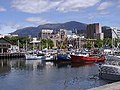 View of Hobart foreshore with Mt Wellington in the background
 -
 Dove Lake at Cradle Mountain, Central Tasmanian Highlands
 -
 Bay of Fires, East Coast ning Tasmania
 -
 Malating pulu lele ning Bruny Island, South East ning Tasmania
 -
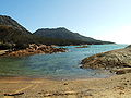 Honeymoon Bay, Freycinet National Park, East Coast ning Tasmania


Lawen ya rin[mag-edit | alilan ya ing pikuwanan]
- Protected areas of Tasmania
- University of Tasmania
- List of schools in Tasmania
- Domestic partnership in Tasmania
Dalerayan[mag-edit | alilan ya ing pikuwanan]
Further reading[mag-edit | alilan ya ing pikuwanan]
- Alexander, Alison (editor) (2005)The Companion to Tasmanian HistoryCentre for Tasmanian Historical Studies, University of Tasmania, Hobart. ISBN 1-86295-223-X.
- Robson, L.L. (1983) A history of Tasmania. Volume 1. Van Diemen's Land from the earliest times to 1855Melbourne, Oxford University Press. ISBN 0-19-554364-5.
- Robson, L.L. (1991) A history of Tasmania. Volume II. Colony and state from 1856 to the 1980s Melbourne, Oxford University Press. ISBN 0-19-553031-4.
Suglung Palwal[mag-edit | alilan ya ing pikuwanan]
Ing Wikimedia Commons atin yang mediang maki kaugnayan kang/king:
- Where is Tasmania? web page Archived Setyembri 8, 2008 at the Wayback Machine
- Tasmania Online - the main State Government website
- Discover Tasmania - official tourism website
- NASA Satellite image of Tasmania Archived Setyembri 22, 2008 at the Wayback Machine
- Another detailed map Archived Pebreru 10, 2009 at the Wayback Machine
States at territoryu ning Australia |
||
|---|---|---|
| States at mainland territoryu |
Australian Capital Territory · New South Wales · Northern Territory · Queensland · South Australia · Tasmania · Victoria · Western Australia · Jervis Bay Territory | |
| External territories | Ashmore and Cartier Islands · Australian Antarctic Territory · Christmas Island · Cocos (Keeling) Islands · Coral Sea Islands · Heard Island and McDonald Islands · Norfolk Island | |