
File:Morina ruins.jpg

Size of this preview: 800 × 538 pixels. Other resolutions: 320 × 215 pixels | 640 × 431 pixels | 1,024 × 689 pixels | 1,280 × 862 pixels | 2,560 × 1,723 pixels | 5,246 × 3,531 pixels.
Ing minunang simpan (file) (5,246 × 3,531 pixel, sukad ning simpan: 12.93 MB, MIME type: image/jpeg)
Sampulung (summary)
| Description |
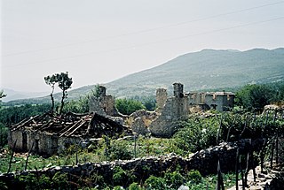
English: Ruins near Morina in the White Drin valley, at the border between Albania and Kosovo. A nearby village is called Planeja, the mountain to the right is called Pastrik. Taken in summer 2001 from a KFOR tank.
These buildings may have been destroyed in the attack, mentioned in the following quote: FOREIGN & COMMONWEALTH OFFICE, LONDON, JUNE 1999 23-24 May |
||
| Petsa | |||
| Pikuanan | Own work | ||
| Maki-akda |
|
| Camera location | | View this and other nearby images on: OpenStreetMap |
|---|
I, the copyright holder of this work, hereby publish it under the following licenses:

|
Permission is granted to copy, distribute and/or modify this document under the terms of the GNU Free Documentation License, Version 1.2 or any later version published by the Free Software Foundation; with no Invariant Sections, no Front-Cover Texts, and no Back-Cover Texts. A copy of the license is included in the section entitled GNU Free Documentation License. |
This file is licensed under the Creative Commons Attribution 3.0 Unported license.
- You are free:
- to share – to copy, distribute and transmit the work
- to remix – to adapt the work
- Under the following conditions:
- attribution – You must give appropriate credit, provide a link to the license, and indicate if changes were made. You may do so in any reasonable manner, but not in any way that suggests the licensor endorses you or your use.
You may select the license of your choice.
Amlat ning simpan (File history)
Mag-click kang petsa/oras ba meng akit ing itsura ning simpan aniang panaun a ita.
| Petsa/Oras | Thumbnail | Sukad | Talagamit | Komentu/Puna | |
|---|---|---|---|---|---|
| salukuyan | 14:11, 7 Marsu 2010 | | 5,246 × 3,531 (12.93 MB) | Watchduck | Reverted to version as of 16:04, 13 December 2009 |
| 20:48, 14 Disyembri 2009 |  | 5,163 × 3,431 (12.44 MB) | Watchduck | color correction | |
| 16:04, 13 Disyembri 2009 |  | 5,246 × 3,531 (12.93 MB) | Watchduck | There was a black border rest on the left side. | |
| 15:57, 13 Disyembri 2009 |  | 5,258 × 3,531 (12.45 MB) | Watchduck | {{Information |Description={{en|1=Ruins near Morina in the White Drin valley, at the border between Albania and Kosovo. Taken in summer 2001 from a KFOR tank.}} |Source={{own}} |Author=[[U |
↓Suglung kareng simpan (''file links'')
Alang bulung a pakasuglung king simpan (file) a ini.
Global file usage
The following other wikis use this file:
- Usage on cs.wikipedia.org
- Usage on de.wikipedia.org
- Usage on en.wikipedia.org
- Usage on en.wikiversity.org
- Usage on fr.wikipedia.org
- Usage on id.wikipedia.org
- Usage on pl.wikipedia.org
- Usage on pt.wikipedia.org
- Usage on ru.wikipedia.org
- Usage on sh.wikipedia.org
- Usage on sq.wikipedia.org
- Usage on sr.wikipedia.org
- Usage on te.wiktionary.org
- Usage on www.wikidata.org
- Usage on zh.wikipedia.org