
File:National-atlas-louisiana.png
Ala nang mas malino pa.
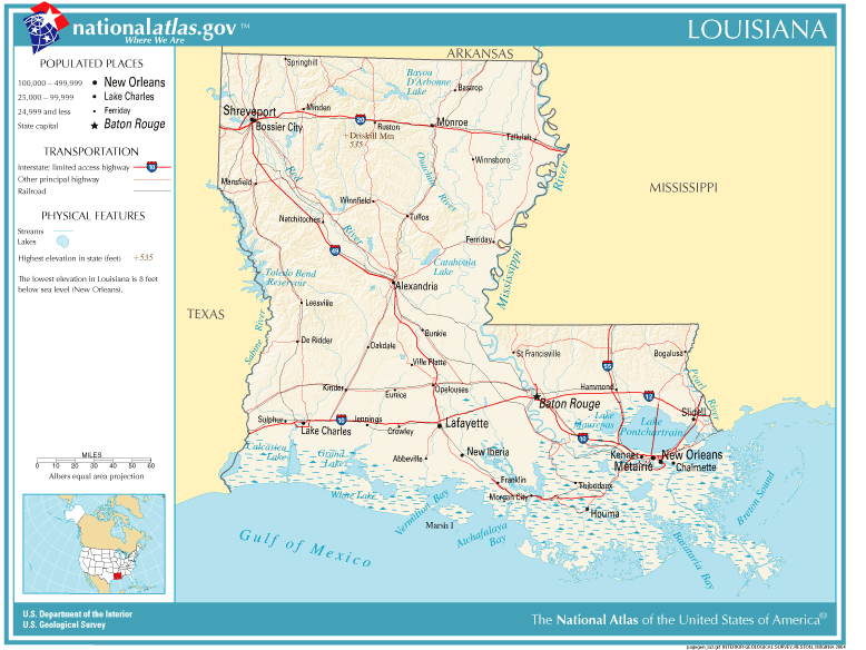
National-atlas-louisiana.png (778 × 584 pixel, sukad ning simpan: 117 KB, MIME type: image/png)
Sampulung (summary)
| Description | Louisiana map |
| Pikuanan | Originally from Image%3ANational-atlas-louisiana.PNG. |
| Maki-akda |
Pamamie lisensia
This map was obtained from an edition of the National Atlas of the United States. Like almost all works of the U.S. federal government, works from the National Atlas are in the public domain in the United States.
Online access: NationalAtlas.gov | 1970 print edition: Library of Congress, Perry-Castañeda Library
|
Wikipedia upload log
(All user names refer to en.wikipedia)
- 2004-11-05 01:28 Queson 778×584×8 (120201 bytes) National Atlas map of Louisiana {{PD-USGov}}
Amlat ning simpan (File history)
Mag-click kang petsa/oras ba meng akit ing itsura ning simpan aniang panaun a ita.
| Petsa/Oras | Thumbnail | Sukad | Talagamit | Komentu/Puna | |
|---|---|---|---|---|---|
| salukuyan | 12:05, 9 Mayu 2007 | | 778 × 584 (117 KB) | Hbk33 | {{Information |Description=en:Category:Louisiana maps |Source=Originally from [http://en.wikipedia.org en.wikipedia]; description page is/was [http://en.wikipedia.org/w/index.php?title=Image%3ANational-atlas-louisiana.PNG here]. |Date=2004-11-05 (ori |
↓Suglung kareng simpan (''file links'')
Ing tutuking page links kaniting simpan (file):
Global file usage
The following other wikis use this file:
- Usage on ar.wikipedia.org
- Usage on en.wikivoyage.org
- Usage on eu.wikipedia.org
- Usage on fr.wikipedia.org
- Usage on gu.wikipedia.org
- Usage on he.wikipedia.org
- Usage on hr.wiktionary.org
- Usage on ja.wikipedia.org
- Usage on kn.wikipedia.org
- Usage on nl.wikipedia.org
- Usage on pl.wikivoyage.org
- Usage on ro.wikipedia.org
- Usage on sw.wikipedia.org
- Usage on tr.wikipedia.org
- Usage on zh-yue.wikipedia.org