
File:Second Severn Crossing pano 1.jpg
Size of this preview: 798 × 138 pixels. Other resolutions: 320 × 55 pixels | 640 × 111 pixels | 1,024 × 177 pixels | 1,280 × 221 pixels | 6,880 × 1,190 pixels.
Ing minunang simpan (file) (6,880 × 1,190 pixel, sukad ning simpan: 1.77 MB, MIME type: image/jpeg)
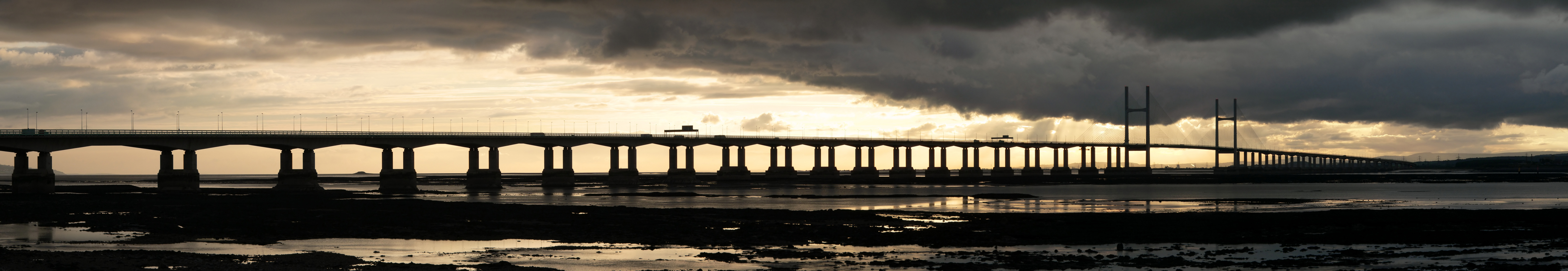
This image was selected as picture of the day on Wikimedia Commons for 30 October 2009. It was captioned as follows: English: The Second Severn Crossing carrying the M4 motorway across the River Severn between Severn Beach near Avonmouth in south west England and Caldicot in south Wales. Other languages:
Bahasa Indonesia: Second Severn Crossing (Jembatan Severn Kedua) yang dilintasi jalan raya M4 melalui Sungai Severn antara Pantai Severn di dekat Avonmouth di barat daya Inggris dan Caldicot di selatan Wales. Bosanski: „Second Severn Crossing“ nosi autoput „M-4“ preko rijeke Severn između Severn Beach-a pored Avonmouth-a u jugozapadnoj Engleskoj i Caldicot-a u južnom Velsu. Čeština: Most Second Severn Crossing, po kterém britská dálnice M4 překonává řeku Severn mezi anglickým Avonmouthem a velšským Caldicotem Dansk: Motorvejsbroen, som fører M4-motorvejen over floden Severn mellem Severn Beach nær Avonmouth i det sydvestlige England og Caldicot i det sydlige Wales. English: The Second Severn Crossing carrying the M4 motorway across the River Severn between Severn Beach near Avonmouth in south west England and Caldicot in south Wales. Español: Segundo puente sobre el río Severn, por el que transcurre la autovía M4 entre Severn Beach (Inglaterra) y Caldicot (País de Gales). Français : Le Second pont sur la rivière Severn, portant l'autoroute M4 entre Severn Beach (Angleterre) et Caldicot (Pays de Galles), vu du coté anglais. Italiano: Il ponte autostradale sul Severn, che collega Severn Beach (in Inghilterra) a Caldicot (in Galles), visto dalla sponda inglese. Magyar: Az angliai Severn-folyót átszelő M4-es autópálya hídja (Avonmouth, délnyugat Anglia és Caldicot, dél Wales között) Nederlands: De Second Severn Crossing, een brug die de Britse autosnelweg M4 over de Severn (de langste rivier van het Verenigd Koninkrijk) draagt, tussen het Engelse dorp Severn Beach (nabij Bristol) en het Welshe stadje Caldicot. Português: Segunda Ponte do Severn (substituta da antiga Ponte do Severn) que cruza o Rio Severn no Reino Unido. Македонски: Вториот премин на реката Северн со автопатот M4 помеѓу југозападна Англија и јужен Велс. বাংলা : সেভেন সেভার্ন ক্রসিংয়ের ওপর অবস্থিত এম৪ সড়কপথ। সেভার্ন নদীর দুই প্রান্ত; পশ্চিম ইংল্যান্ডের অ্যাভনমাউথ ও দক্ষিণ ওয়েলসের ক্যালডিকট অঞ্চলকে যুক্ত করে এর অবস্থান। |
Sampulung (summary)
| Description |
English: The Second Severn Crossing carrying the M4 motorway across the River Severn between Severn Beach near Avonmouth in south west England and Caldicot in south Wales. This view, composed from 16 separate images, is looking west from the English side. The bridge has a total span of 5.1 km and includes a cable-stayed section called the Shoots Bridge which spans the shipping channel between the two towers. The River Severn has a vast tidal range - the point from which this photograph was taken would be covered at high tide.
Français : Le Second pont sur la rivière Severn, portant l'autoroute M4 entre Severn Beach (Angleterre) et Caldicot (Pays de Galles), vu du coté anglais. Le pont a une portée totale de 5,1 km et possède une section nommée Shoots Bridge par dessus le chenal navigable. La rivière Severn à une très forte marée. Le point d'où la photo a été prise est couvert par les hautes eaux. Cette vue panoramique est constituée à partir de 16 images séparées. |
| Petsa | |
| Pikuanan | Own work |
| Maki-akda | Yummifruitbat |
| Permission (Reusing this file) |
CC-BY-SA 2.5 |
| Other versions | Derivative works of this file: Severn Crossing banner.jpg |
| Camera location | | View this and other nearby images on: OpenStreetMap |
|---|
|

Pamamie lisensia
I, the copyright holder of this work, hereby publish it under the following license:
This file is licensed under the Creative Commons Attribution-Share Alike 2.5 Generic license.
- You are free:
- to share – to copy, distribute and transmit the work
- to remix – to adapt the work
- Under the following conditions:
- attribution – You must give appropriate credit, provide a link to the license, and indicate if changes were made. You may do so in any reasonable manner, but not in any way that suggests the licensor endorses you or your use.
- share alike – If you remix, transform, or build upon the material, you must distribute your contributions under the same or compatible license as the original.
Amlat ning simpan (File history)
Mag-click kang petsa/oras ba meng akit ing itsura ning simpan aniang panaun a ita.
| Petsa/Oras | Thumbnail | Sukad | Talagamit | Komentu/Puna | |
|---|---|---|---|---|---|
| salukuyan | 22:40, 14 Setyembri 2006 | 6,880 × 1,190 (1.77 MB) | Yummifruitbat | {{Information |Description=The Second Severn Crossing carrying the M4 motorway across the River Severn between Severn Beach near Avonmouth in south west [ |
↓Suglung kareng simpan (''file links'')
Ing tutuking page links kaniting simpan (file):
Global file usage
The following other wikis use this file:
- Usage on bn.wikipedia.org
- Usage on crh.wikipedia.org
- Usage on cv.wikipedia.org
- Usage on da.wikipedia.org
- Usage on de.wikipedia.org
- Usage on en.wikipedia.org
- Usage on en.wikibooks.org
- Usage on fr.wikipedia.org
- Usage on hu.wikipedia.org
- Usage on id.wikipedia.org
- Usage on ko.wikipedia.org
- Usage on krc.wikipedia.org
- Usage on lbe.wikipedia.org
- Usage on mg.wikipedia.org
- Usage on mk.wikipedia.org
- Usage on no.wikipedia.org
- Usage on os.wikipedia.org
- Usage on pl.wikipedia.org
- Usage on pt.wikipedia.org
- Usage on ru.wikipedia.org
- Usage on ru.wikinews.org
- Usage on sah.wikipedia.org
- Usage on uk.wikipedia.org
- Usage on vi.wikipedia.org
- Usage on xal.wikipedia.org
- Usage on zh.wikipedia.org