
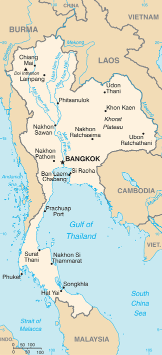
File:Thailand map CIA.png
Size of this preview: 273 × 599 pixels. Other resolutions: 109 × 240 pixels | 324 × 711 pixels.
Ing minunang simpan (file) (324 × 711 pixel, sukad ning simpan: 37 KB, MIME type: image/png)
This image is in the public domain because it contains materials that originally came from the United States Central Intelligence Agency's World Factbook.
|
 |
Amlat ning simpan (File history)
Mag-click kang petsa/oras ba meng akit ing itsura ning simpan aniang panaun a ita.
| Petsa/Oras | Thumbnail | Sukad | Talagamit | Komentu/Puna | |
|---|---|---|---|---|---|
| salukuyan | 15:05, 13 Marsu 2022 | | 324 × 711 (37 KB) | Lojwe | Cropped 2 % horizontally, 1 % vertically using CropTool with precise mode. |
| 20:09, 8 Setyembri 2012 |  | 330 × 715 (64 KB) | Thricecube | Updated version of the map | |
| 12:06, 2 Disyembri 2004 |  | 331 × 708 (20 KB) | Ahoerstemeier |
↓Suglung kareng simpan (''file links'')
Ing tutuking page links kaniting simpan (file):
Global file usage
The following other wikis use this file:
- Usage on ace.wikipedia.org
- Usage on als.wikipedia.org
- Usage on ast.wikipedia.org
- Usage on bbc.wikipedia.org
- Usage on be-tarask.wikipedia.org
- Usage on bg.wikipedia.org
- Usage on bn.wikipedia.org
- Usage on ca.wikipedia.org
- Usage on ckb.wikipedia.org
- Usage on da.wikipedia.org
- Usage on en.wikipedia.org
- Usage on en.wikinews.org
- Usage on es.wikipedia.org
- Usage on fa.wikipedia.org
- Usage on fiu-vro.wikipedia.org
- Usage on fi.wikipedia.org
- Usage on fi.wikivoyage.org
- Usage on fo.wikipedia.org
- Usage on fy.wikipedia.org
- Usage on he.wikipedia.org
- Usage on id.wikipedia.org
- Usage on incubator.wikimedia.org
- Usage on it.wikipedia.org
- Usage on it.wikinews.org
- Usage on ja.wikipedia.org
- Usage on jv.wikipedia.org
- Usage on ka.wikipedia.org
- Usage on km.wikipedia.org
- Usage on ko.wikipedia.org
- Usage on la.wikipedia.org
- Usage on lfn.wikipedia.org
- Usage on lt.wikipedia.org
- Usage on mdf.wikipedia.org
- Usage on ml.wikipedia.org
- Usage on mn.wikipedia.org
- Usage on mr.wikipedia.org
- Usage on ms.wikipedia.org
View more global usage of this file.