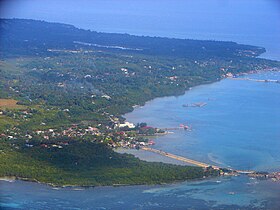
Dauis
Appearance
Dauis | |
|---|---|
 | |
 Mapa ning Bohol ampong Dauis ilage | |
 | |
| Puuk: 9°37'30"N, 123°51'54"E | |
| Bansa | Filipinas |
| Labuad | Kalibudtang Visayas (Rehiyong VII) |
| Lalawigan | Bohol |
| Tuknangan | Balen |
| Barangay | 12 |
| Sukad | |
| • Kabilugan | 43.33 km2 (16.73 sq mi) |
| Elebasyun | 34 m (112 ft) |
| Populasyun (Sensu ning 1 Mayu 2020) | |
| • Kabilugan | 52,492 |
| • Densidad | 1,200/km2 (3,100/sq mi) |
| • Pamimalemale | 11,522 |
| Economia | |
| • Uryan | pangapat yang klasing balen |
| • Panakitan | ₱165,302,277.58 (2020) |
| • Activos | ₱413,078,024.35 (2020) |
| • Pasivos | ₱59,780,956.30 (2020) |
| • Gastos | ₱138,843,141.59 (2020) |
| Kodigo Postal | 6339 |
| PSGC | |
| IDD : area code | +63 (0)38 |
| Amanu | Boholano dialect amánung Sebuánu Tagálug |
| Websayt | dauis.bohol.gov.ph |
Ing Dauis pang4 yang klasing balen king lalawigan ning Bohol, Filipinas. Agpang keng 1 Mayu 2020 ning sensus, atin yang populasyun a 52,492 a katau kareng 11,522 a pamimalemale.
Deng Barangay
[mag-edit | alilan ya ing pikuwanan]Ing Dauis atin yang 12ng Barangay.
- Biking
- Banggang
- San Isidro (Canlongon)
- Cartman
- Dio
- Mayacabac
- Poblacion
- Songculan
- Tabalong
- Tinago
- Totolan
- Mariveles
Demograpiku
[mag-edit | alilan ya ing pikuwanan]| Taun | Pop. | ±% p.a. |
|---|---|---|
| 1903 | 8,378 | — |
| 1918 | 10,275 | +1.37% |
| 1939 | 12,154 | +0.80% |
| 1948 | 12,303 | +0.14% |
| 1960 | 13,595 | +0.84% |
| 1970 | 15,812 | +1.52% |
| 1975 | 17,955 | +2.58% |
| 1980 | 18,260 | +0.34% |
| 1990 | 23,601 | +2.60% |
| 1995 | 24,041 | +0.35% |
| 2000 | 26,415 | +2.04% |
| 2007 | 36,525 | +4.57% |
| 2010 | 39,448 | +2.84% |
| 2015 | 45,663 | +2.83% |
| 2020 | 52,492 | +2.78% |
| Sanggunian: Philippine Statistics Authority[1][2][3][4] | ||
Panibatan
[mag-edit | alilan ya ing pikuwanan]- ↑ Census of Population (2015). "Total Population by Province, City, Municipality and Barangay". Total Population by Province, City, Municipality and Barangay. PSA.
- ↑ Census of Population and Housing (2010). "Total Population by Province, City, Municipality and Barangay". Total Population by Province, City, Municipality and Barangay. NSO.
- ↑ Censuses of Population (1903–2007). "Table 1. Population Enumerated in Various Censuses by Province/Highly Urbanized City: 1903 to 2007". Table 1. Population Enumerated in Various Censuses by Province/Highly Urbanized City: 1903 to 2007. NSO. https://archive.org/download/PhilippinesCensusofPopulationLGUs19032007/Region%207%20Central%20Visayas%20Philippines%20Census%20of%20Population%201903%20-%202007.xlsx.
- ↑ Province of. Municipality Population Data. Local Water Utilities Administration Research Division. Retrieved on [[Disiembri 17, 2016]].
Suglung Palwal
[mag-edit | alilan ya ing pikuwanan]- PhilAtlas.com
- Philippine Standard Geographic Code
- Local Governance Performance Management System
- The Mystery of the Virgin Mary on a Tree, Totolan, Dauis Archived Mayu 3, 2009 at the Wayback Machine
- Serene Place at Songculan, Dauis Bohol Archived Juliu 20, 2009 at the Wayback Machine
| Tagbilaran (kapitolyo) | |
| Balen | Alburquerque ▪ Alicia ▪ Anda ▪ Antequera ▪ Baclayon ▪ Balilihan ▪ Batuan ▪ Bien Unido ▪ Bilar ▪ Buenavista ▪ Calape ▪ Candijay ▪ Carmen ▪ Catigbian ▪ Clarin ▪ Corella ▪ Cortes ▪ Dagohoy ▪ Dáno ▪ Dauis ▪ Dimiao ▪ Duero ▪ Garcia Hernandez ▪ Getafe ▪ Guindulman ▪ Inabanga ▪ Jagna ▪ Lila ▪ Loay ▪ Loboc ▪ Loon ▪ Mabini ▪ Maribojoc ▪ Panglao ▪ Pilar ▪ President Carlos P. Garcia ▪ Sagbayan ▪ San Isidro ▪ San Miguel ▪ Sevilla ▪ Sierra Bullones ▪ Sikatuna ▪ Talibon ▪ Trinidad ▪ Tubigon ▪ Ubay ▪ Valencia |
| Lakanbalen | Tagbilaran |
