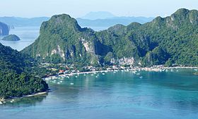
El Nido
Appearance
El Nido | |
|---|---|
 | |
 Mapa ning Palawan ampong El Nido ilage | |
 | |
| Puuk: 11°11'44.02"N, 119°24'27.00"E | |
| Bansa | Filipinas |
| Labuad | Mimaropa (Rehiyong IV-B) |
| Lalawigan | Palawan |
| Tuknangan | Balen |
| Barangay | 18 |
| Sukad | |
| • Kabilugan | 923.26 km2 (356.47 sq mi) |
| Elebasyun | 35 m (115 ft) |
| Populasyun (Sensu ning 1 Mayu 2020) | |
| • Kabilugan | 50,494 |
| • Densidad | 55/km2 (140/sq mi) |
| • Pamimalemale | 12,632 |
| Economia | |
| • Uryan | primeru klasing balen |
| • Panakitan | ₱444,279,101.23145,363,127.68164,619,221.22200,114,900.25246,049,031.09196,808,586.54346,678,619.70420,923,922.01486,280,791.38386,797,245.64582,112,475.24 (2020) |
| • Activos | ₱1,412,973,784.81138,503,431.67169,602,861.49240,712,870.02359,207,156.02480,475,579.06701,315,134.63908,530,099.421,202,914,331.971,537,555,928.571,736,640,029.96 (2020) |
| • Pasivos | ₱416,951,883.4251,677,222.1060,863,729.1178,432,475.93101,406,551.93116,143,064.06200,777,123.86209,304,648.85340,854,387.634,778,112,753.94529,158,315.67 (2020) |
| • Gastos | ₱322,280,556.96127,559,842.82141,245,348.01145,737,144.66170,915,180.31191,128,428.74210,334,777.86250,302,902.97294,975,876.34327,949,733.06378,781,291.60 (2020) |
| Kodigo Postal | 5313 |
| PSGC | |
| IDD : area code | +63 (0)48 |
| Amanu | Palawano Tagálug |
| Websayt | www.elnidopalawan.gov.ph |
Ing El Nido pang4 yang klasing balen king lalawigan ning Palawan, Filipinas. Agpang keng 1 Mayu 2020 ning sensus, atin yang populasyun a 50,494 a katau kareng 12,632 a pamimalemale.
Deng Barangay
[mag-edit | alilan ya ing pikuwanan]
|
|
Demograpiku
[mag-edit | alilan ya ing pikuwanan]| Taun | Pop. | ±% p.a. |
|---|---|---|
| 1918 | 1,789 | — |
| 1939 | 2,280 | +1.16% |
| 1948 | 2,306 | +0.13% |
| 1960 | 4,075 | +4.86% |
| 1970 | 7,358 | +6.08% |
| 1975 | 8,749 | +3.53% |
| 1980 | 11,657 | +5.91% |
| 1990 | 18,832 | +4.91% |
| 1995 | 21,948 | +2.91% |
| 2000 | 27,029 | +4.57% |
| 2007 | 30,249 | +1.56% |
| 2010 | 36,191 | +6.74% |
| 2015 | 41,606 | +2.69% |
| 2020 | 50,494 | +3.88% |
| Sanggunian: Philippine Statistics Authority[1][2][3][4] | ||
Panibatan
[mag-edit | alilan ya ing pikuwanan]- ↑ Census of Population (2015). "Total Population by Province, City, Municipality and Barangay". Total Population by Province, City, Municipality and Barangay. PSA.
- ↑ Census of Population and Housing (2010). "Total Population by Province, City, Municipality and Barangay". Total Population by Province, City, Municipality and Barangay. NSO.
- ↑ Censuses of Population (1903–2007). "Table 1. Population Enumerated in Various Censuses by Province/Highly Urbanized City: 1903 to 2007". Table 1. Population Enumerated in Various Censuses by Province/Highly Urbanized City: 1903 to 2007. NSO. https://archive.org/download/PhilippinesCensusofPopulationLGUs19032007/Region%204B%20Mimaropa%20Philippines%20Census%20of%20Population%201903%20-%202007.xls.
- ↑ Province of. Municipality Population Data. Local Water Utilities Administration Research Division. Retrieved on [[Disiembri 17, 2016]].
Suglung Palwal
[mag-edit | alilan ya ing pikuwanan]- PhilAtlas.com
- Philippine Standard Geographic Code
- Local Governance Performance Management System
- El Nido Tourist information centre
- EL NIDO PALAWAN RESERVATIONS AND INFORMATION SERVICE
- MAPS OF EL NIDO.PALAWAN.PHILIPPINES.DIVE MAPS.FLIGHT MAPS FOR EL NIDO
- Sunset lovers beach cottages
- Taiyo beach cottages
- Hadefes beach cottages
- FLIGHT TIME TABLE TO EL NIDO
- ACCOMMODATION IN EL NIDO
- EL NIDOS RESTAURANTS
- DIVING IN EL NIDO
- BUS TIMES FOR EL NIDO
- FERRY TIMES FOR EL NIDO
- EMAIL INFORMATION CONTACT FOR EL NIDO
- Philippine Standard Geographic Code Archived Abril 13, 2012 at the Wayback Machine
- 2000 Philippine Census Information Archived Setyembri 23, 2005 at the Wayback Machine
- El Nido Resorts Archived Marsu 16, 2007 at the Wayback Machine
- Official Website of El Nido Tourism Office
- Dolarog website
- El Nido Scuba website
- Seacology reef rehabilitation project in El Nido Archived Pebreru 27, 2007 at the Wayback Machine Seacology
- El Nido Palawan Philippines diving sites
| Puerto Princesa (kapitolyo) | |
| Balen | Aborlan ▪ Agutaya ▪ Araceli ▪ Balabac ▪ Bataraza ▪ Brooke's Point ▪ Busuanga ▪ Cagayancillo ▪ Coron ▪ Culion ▪ Cuyo ▪ Dumaran ▪ El Nido ▪ Kalayaan ▪ Linapacan ▪ Magsaysay ▪ Narra ▪ Quezon ▪ Rizal ▪ Roxas ▪ San Vicente ▪ Sofronio Española ▪ Taytay |
| Maragul Lakanbalen | Puerto Princesa |
