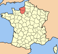
Haute-Normandie
Appearance
| Labuad Haute-Normandie | ||
|---|---|---|
| Karinan | ||
| ||
| Administrasyun | ||
| Tungku | Rouen | |
| Labuad Pamuntuk | Alain Le Vern (PS) (since 1998) | |
| Departamentu | Eure Seine-Maritime | |
| Arrondissements | 6 | |
| Cantons | 112 | |
| Commune | 1,420 | |
| Statistics | ||
| Gabun lapad1 | 12,317 km² | |
| Populasyun | (Ranked 13th) | |
| - Eneru 1, 2006 est. | 1,811,000 | |
| - Marsu 8, 1999 census | 1,780,192 | |
| - Pangasiksik (2006) | 147/km² | |
| 1 French Land Register data, which exclude lakes, ponds, and glaciers larger than 1 km² (0.386 sq. mi. or 247 acres) as well as the estuaries of rivers 2 This is the flag of Normandy, which is also used by the Lower Normandy région. | ||
Ing Haute-Normandie (Upper Normandy) metung ya kareng 26 a labuad ning France. Melalang ya iti inyang 1956, inyang ing Normandy megnadake ya bilang Basse-Normandie at Haute-Normandie.
Pun communidad
[mag-edit | alilan ya ing pikuwanan]- Dieppe
- Évreux
- Fécamp
- Le Grand-Quevilly
- Le Havre
- Le Petit-Quevilly
- Mont-Saint-Aignan
- Rouen
- Saint-Étienne-du-Rouvray
- Sotteville-lès-Rouen
- Vernon
Lawen ya rin
[mag-edit | alilan ya ing pikuwanan]Suglung Palwal
[mag-edit | alilan ya ing pikuwanan]- Région Haute-Normandie Official website
Template:Haute-Normandie-geo-stub

