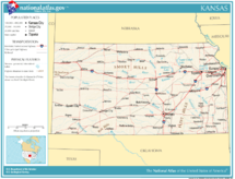
Kansas
Appearance
- Ing artikulung iti tungkul ya keng the U.S. State. Para kareng aliwang kabaldugan na niti, Kansas (disambiguation).
| |||||||||
| Peka Amanu | English | ||||||||
| Tungku Pekamaragul a Lakanbalen |
Topeka Wichita | ||||||||
| Lapad - Eganagana - Lapad - Kaba - % danum - Latitude - Longitude |
Ranku 15th 82,277 sq mi 213,096 km² 211 milya 340 km 400 milya 645 km 0.56 37°N to 40°N 94°38'W to 102°1'34"W | ||||||||
| Populasyun - Total (2000) - Pangasiksik |
Ranku 32nd 2,688,418 32.9/sq. mi 12.7/km² (40th) | ||||||||
| Elevation - Pekamatas a lugal - Kaustuan - Pekamababang Lugal |
Mount Sunflower—4,039 pie 1,231 m 2,000 pie 600 m 679 pie 207 m | ||||||||
| Pangatanggap keng Union | January 29, 1861 (34th) | ||||||||
| Gobernador Deng U.S. Senators |
Jeff Colyer (R) Jerry Moran (R) Pat Roberts (R) | ||||||||
| Oras zona | Central : UTC-6/-5 Mountain: UTC-7/-6 Counties are Central except for 4 counties on western border. | ||||||||
| Abbreviations | KS US-KS | ||||||||
| Web site | www.kansas.gov | ||||||||


| Dake Politiku ning United States | |
|---|---|
| States | Alabama | Alaska | Arizona | Arkansas | California | Colorado | Connecticut | Delaware | Florida | Georgia | Hawaii | Idaho | Illinois | Indiana | Iowa | Kansas | Kentucky | Louisiana | Maine | Maryland | Massachusetts | Michigan | Minnesota | Mississippi | Missouri | Montana | Nebraska | Nevada | New Hampshire | New Jersey | New Mexico | New York | North Carolina | North Dakota | Ohio | Oklahoma | Oregon | Pennsylvania | Rhode Island | South Carolina | South Dakota | Tennessee | Texas | Utah | Vermont | Virginia | Washington | West Virginia | Wisconsin | Wyoming |
| Federal district | District of Columbia |
| Insular areas | American Samoa | Guam | Northern Mariana Islands | Puerto Rico | Virgin Islands |
| COFA | Republic of the Marshall Islands | Republic of Palau | Federated States of Micronesia |
| Minor outlying islands | Baker Island | Howland Island | Jarvis Island | Johnston Atoll | Kingman Reef | Midway Atoll | Navassa Island | Palmyra Atoll | Wake Island |


