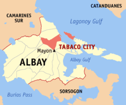
Tabaco
Appearance
Tabaco | |
|---|---|
 | |
 Mapa ning Albay ampong Tabaco ilage | |
 | |
| Puuk: 13°21'N, 123°44'E | |
| Bansa | Filipinas |
| Labuad | Labuad Bicol (Rehiyong V) |
| Lalawigan | Albay |
| Tuknangan | Lakanbalen |
| Mitatag | 1731 |
| Barangay | 47 |
| Sukad | |
| • Kabilugan | 117.14 km2 (45.23 sq mi) |
| Elebasyun | 168 m (551 ft) |
| Populasyun (Sensu ning 1 Mayu 2020) | |
| • Kabilugan | 140,961 |
| • Densidad | 1,200/km2 (3,100/sq mi) |
| • Pamimalemale | 31,415 |
| Economia | |
| • Uryan | pangapat yang klasing lakanbalen |
| • Panakitan | ₱731,229,800.41340,179,491.66359,451,091.34407,131,165.43448,570,707.28491,643,976.03561,192,835.78612,423,025.99678,462,730.94785,721,089.461,032,434,514.70 (2020) |
| • Activos | ₱2,691,764,785.491,171,634,511.871,195,577,223.321,167,718,967.981,377,446,177.491,537,692,795.601,743,701,175.391,918,905,921.492,181,739,470.093,069,854,912.383,518,729,361.23 (2020) |
| • Pasivos | ₱653,741,839.19228,745,577.36194,684,998.90130,985,857.50273,199,190.29312,021,107.15338,041,794.98289,105,269.31369,339,909.79652,287,169.26459,647,737.73 (2020) |
| • Gastos | ₱551,584,816.57225,597,233.43228,714,574.78219,423,814.89247,923,080.91273,206,776.34402,344,880.92443,511,082.04468,007,265.56513,012,918.21672,920,791.85 (2020) |
| Kodigo Postal | 4511 |
| PSGC | |
| IDD : area code | +63 (0)52 |
| Amanu | Central Bikol Albay Bikol Tagálug |
| Websayt | www.tabacocity.com.ph |
Ing Lakanbalen ning Tabaco pang4 yang klasing lakanbalen king lalawigan ning Albay, Filipinas. Agpang keng 1 Mayu 2020 ning sensus, atin yang populasyun a 140,961 a katau kareng 31,415 a pamimalemale.
Deng Barangay
[mag-edit | alilan ya ing pikuwanan]Ing Tabaco Lakanbalen atin yang 47ng barangay.
|
|
|
Demograpiku
[mag-edit | alilan ya ing pikuwanan]| Taun | Pop. | ±% p.a. |
|---|---|---|
| 1903 | 21,946 | — |
| 1918 | 24,812 | +0.82% |
| 1939 | 29,957 | +0.90% |
| 1948 | 33,209 | +1.15% |
| 1960 | 46,416 | +2.83% |
| 1970 | 60,572 | +2.69% |
| 1975 | 65,254 | +1.50% |
| 1980 | 72,634 | +2.17% |
| 1990 | 85,697 | +1.67% |
| 1995 | 96,993 | +2.35% |
| 2000 | 107,166 | +2.16% |
| 2007 | 123,513 | +1.98% |
| 2010 | 125,083 | +0.46% |
| 2015 | 133,868 | +1.30% |
| 2020 | 140,961 | +1.02% |
| Sanggunian: Philippine Statistics Authority[1][2][3][4] | ||
Panibatan
[mag-edit | alilan ya ing pikuwanan]- ↑ Census of Population (2015). "Total Population by Province, City, Municipality and Barangay". Total Population by Province, City, Municipality and Barangay. PSA.
- ↑ Census of Population and Housing (2010). "Total Population by Province, City, Municipality and Barangay". Total Population by Province, City, Municipality and Barangay. NSO.
- ↑ Censuses of Population (1903–2007). "Table 1. Population Enumerated in Various Censuses by Province/Highly Urbanized City: 1903 to 2007". Table 1. Population Enumerated in Various Censuses by Province/Highly Urbanized City: 1903 to 2007. NSO. https://archive.org/download/PhilippinesCensusofPopulationLGUs19032007/Region%205%20Bicol%20Region%20Philippines%20Census%20of%20Population%201903%20-%202007.xls.
- ↑ Province of Albay. Municipality Population Data. Local Water Utilities Administration Research Division. Retrieved on [[Disiembri 17, 2016]].
Suglung Palwal
[mag-edit | alilan ya ing pikuwanan]- PhilAtlas.com
- Philippine Standard Geographic Code
- Local Governance Performance Management System
- Official web page
- 2000 Philippine Census Information Archived Setyembri 23, 2005 at the Wayback Machine
| Legazpi (kapitolyo) | |
| Balen | Bacacay ▪ Camalig ▪ Daraga ▪ Guinobatan ▪ Jovellar ▪ Libon ▪ Malilipot ▪ Malinao ▪ Manito ▪ Oas ▪ Pio Duran ▪ Polangui ▪ Rapu-Rapu ▪ Santo Domingo ▪ Tiwi |
| Lakanbalen | Legazpi ▪ Ligao ▪ Tabaco |
