Parañaque
Appearance
Parañaque | |
|---|---|
 | |
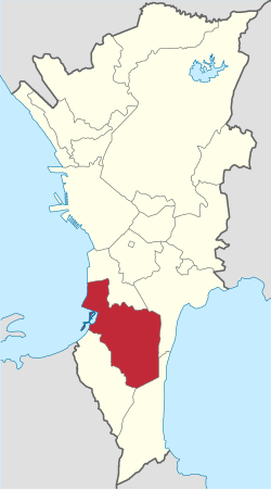
 Mapa ning Keragúlang Menílâ ampong Parañaque ilage | |
 | |
| Puuk: 14°30'2.9"N, 120°59'29.4"E | |
| Bansa | Filipinas |
| Labuad | Keragúlang Menílâ |
| Lalawigan | Keragúlang Menílâ |
| Tuknangan | Maragul Lakanbalen |
| Barangay | 16 |
| Pamamahala | |
| • Alkaldi | Eric Olivarez |
| Sukad | |
| • Kabilugan | 46.57 km2 (17.98 sq mi) |
| Elebasyun | 11 m (36 ft) |
| Populasyun (Sensu ning 1 Mayu 2020) | |
| • Kabilugan | 689,992 |
| • Densidad | 15,000/km2 (38,000/sq mi) |
| • Pamimalemale | 182,216 |
| Economia | |
| • Uryan | primeru klasing lakanbalen |
| • Panakitan | ₱7,924,495,749.00 (2020) |
| • Activos | ₱14,896,277,723.00 (2020) |
| • Pasivos | ₱4,796,329,037.00 (2020) |
| • Gastos | ₱6,182,055,478.00 (2020) |
| Kodigo Postal | 1700–1720 |
| PSGC | |
| IDD : area code | +63 (0)02 |
| Amanu | Tagálug |
| Websayt | paranaquecity.gov.ph |
Ing Lakanbalen Parañaque , metung ya karing Lakanbalen at balen a bubuu keng Keragulang Menila (Metro Manila)—ing Labuad Bangsang Tungku. Makasepu ya king pangulu ning Pasay Lakanbalen, ning Taguig Lakanbalen king pangulungaslagan, Muntinlupa Lakanbalen king mauling aslagan, ning Las Piñas Lakanbalen king mauling albugan, at ning Manila Bay king albugan. Agpang keng 1 Mayu 2020 ning sensus, atin yang populasyun a 689,992 a katau kareng 182,216 a pamimalemale.
Ding Distritu at ding Barangay
[mag-edit | alilan ya ing pikuwanan]Walung Barangay - Distritu 1
[mag-edit | alilan ya ing pikuwanan]- Baclaran
- Don Galo
- La Huerta
- San Donisio
- San Isidro
- Sto. Niño
- Tambo
- Vitalez
Walung Barangay - Distritu 2
[mag-edit | alilan ya ing pikuwanan]- B.F. Homes
- Don Bosco
- Marcelo Green
- Merville
- Moonwalk
- San Antonio
- San Martin de Porres
- Sun Valley
Subdibisyun
[mag-edit | alilan ya ing pikuwanan]- B.F. Homes Parañaque
- Better Living Subdivision
- Camella Homes Sucat
- Gatchalian 1 Subdivision
- Goodwill II Subdivision
- Goodwill III Subdivision
- Ireneville
- Marcelo Green Village
- Merville Subdivision
- Multinational Village
- San Antonio Valley (numerous phases)
- Severina Diamond Subdivision Km.18
- Sun Valley Subdivision
- United Parañaque Subdivision
- Parañaque Greenheights
- Teoville East & West
- Teoville 3
- Maywood (numerous village)
- Tahanan Village
- Salvador Estate
- Fourth Estate Subdivision
Pipasyalan
[mag-edit | alilan ya ing pikuwanan]- St. Andrew's Cathedral (Barangay La Huerta), the seat of Diocese of Parañaque
- Ninoy Aquino International Airport Terminal 1
- Baclaran Redemptorist Church, one of the biggest and most active churches in the country where devotees flock to hear mass every Wednesday
- Casino Filipino
- Manila Memorial Park, the country's first memorial park and resting place to some of the country's most celebrated personalities
- Loyola Memorial Park, part of one of the country's chain of memorial parks
- Fiesta Shopping Mall (Duty Free Philippines)
- SM Lakanbalen Sucat, part of the country's biggest chain of malls
- SM Lakanbalen Bicutan, part of the country's biggest chain of malls
- El Shaddai
- Paranaque Lakanbalen Hall
- Academic Institusyun
- Airlink International Flying School
- Informatics Computer Institute
- Immaculate Heart of Mary College
- Manresa School
- St. Andrew's School
- St. Cyr Academy
- St. James College of Parañaque
- St. Paul College of Parañaque
- St. Rita College and Orphanage
- Parañaque Lakanbalen College of Science and Technology
- PATTS College of Aeronautics
- Philippine State College of Aeronautics
- Centro Escolar University's Generosa de Leon Integrated School (now defunct)
- Olivarez College
- AMA Computer College
- STI Computer College
- Universal College of Nursing
- Veritas Parochial School
- St. Francis School of Assisi
- Philippine Christian University
- Lycee d'Regis Marie School
- Davidville Academy
- Marymount School
- Ramon Pascual Institute
- Regis Grace Montessori School (Annex)
- Madre Maria Pia Notari School
- Parañaque National High School
- Parañaque National High School (Annex)
Demograpiku
[mag-edit | alilan ya ing pikuwanan]| Taun | Pop. | ±% p.a. |
|---|---|---|
| 1903 | 6,507 | — |
| 1918 | 22,121 | +8.50% |
| 1939 | 21,125 | −0.22% |
| 1948 | 28,884 | +3.54% |
| 1960 | 61,898 | +6.56% |
| 1970 | 97,214 | +4.61% |
| 1975 | 158,974 | +10.37% |
| 1980 | 208,552 | +5.58% |
| 1990 | 308,236 | +3.98% |
| 1995 | 391,296 | +4.57% |
| 2000 | 449,811 | +3.03% |
| 2007 | 552,660 | +2.88% |
| 2010 | 588,126 | +2.29% |
| 2015 | 665,822 | +2.39% |
| 2020 | 689,992 | +0.70% |
| Sanggunian: Philippine Statistics Authority[1][2][3][4] | ||
Panibatan
[mag-edit | alilan ya ing pikuwanan]- ↑ Census of Population (2015). "Total Population by Province, City, Municipality and Barangay". Total Population by Province, City, Municipality and Barangay. PSA.
- ↑ Census of Population and Housing (2010). "Total Population by Province, City, Municipality and Barangay". Total Population by Province, City, Municipality and Barangay. NSO.
- ↑ Censuses of Population (1903–2007). "Table 1. Population Enumerated in Various Censuses by Province/Highly Urbanized City: 1903 to 2007". Table 1. Population Enumerated in Various Censuses by Province/Highly Urbanized City: 1903 to 2007. NSO. https://archive.org/download/PhilippinesCensusofPopulationLGUs19032007/NCR%20Philippines%20Census%20of%20Population%201903%20-%202007.xls.
- ↑ Province of. Municipality Population Data. Local Water Utilities Administration Research Division. Retrieved on [[Disiembri 17, 2016]].
Ding suglung a palual
[mag-edit | alilan ya ing pikuwanan]- PhilAtlas.com
- Philippine Standard Geographic Code
- Local Governance Performance Management System
- Parañaque City Official Website
- http://www.geocities.com/palanyag/: Palanyag - Parañaque Lakanbalen Info
